A Note on Dating:
In the timeline each entry is assigned to one particular date. Many of the periods or sites discussed span a long period of time - in general, they are listed by the date that marks the start of that period. For example, many entries about Archaic Greece, its art and certain sites are listed as 600 BC, the beginning of the Archaic period.
Many of these dates are approximate due to lack of evidence (particularly those from the prehistoric period). Certain dates denote a particular moment in the history of the entry – for example, discussion about imperial Rome has been dated at 27 BC, the year in which Octavian became Augustus; Pompeii has been dated to 79 AD, the date of the eruption of Vesuvius. Some sites, such as Rome and Athens, are listed more than once under a number of dates to reflect the different periods covered.

The Neolithic Revolution
The varied geography of the Near East is a key to cultural developments in the Neolithic (8550-5000 BC) and later periods. Areas of well-watered plateaus, hills, and river valleys contrast with high mountains and desert.
During this period, the nature of food production saw radical changes. Heretofore, humans lived off wild plants and animals. Now, domesticates were developed, leading to agriculture and animal husbandry: human control over food resources. The earliest experiments in these new types of food resources took place in the so-called Fertile Crescent (an area stretching in an arc from Syria-Palestine north to south-east Turkey then south-east into Iran) and into the Anatolian plateau, regions with a flora, fauna, geography, and climate favorable for such changes.
A vast array of social changes accompanied these dramatic developments in food production. Among them was the rise of sedentary settlement, a prelude to the eventual development of towns and cities. So important were these changes that the phrase "Neolithic Revolution" has commonly been used to describe them.
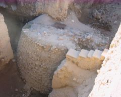
Neolithic Jericho
Two early levels from this long-inhabited city have given important evidence for the development of towns in the Pre-Pottery Neolithic ("PPN") A and B phases, ca. 8500-6000 BC. Features include a fortification wall, indicating a need for serious protection, but against what or whom? Houses, made of mud brick, were first round, later rectangular, eventually decorated with painted plaster walls, plastered floors, and reed mats. Below the floor of one house ten human skulls were discovered, the flesh recreated with plaster, the eyes marked by pieces of shell. They may attest to a cult of ancestors. Contact with distant lands is marked by finds of obsidian, brought from Anatolia. The prosperous PPNB settlement came to an end for unknown reasons.

Göbekli Tepe, Turkey
This ceremonial center of the PPNA and PPNB periods has contributed unusual evidence about the religious life of early Neolithic people in south-east Anatolia. Situated on a hillside prominent in the landscape, the architecture consists largely of circular buildings, maximum 12m in diameter, perhaps originally sunk into the ground, with 5m-tall stone piers that held up the ceiling. The piers are often carved with images of insects, reptiles, and menacing beasts, sometimes with stylized human arms and hands. The images surely connected with the beliefs and ceremonies of those who gathered here long ago, but their meaning eludes us today.

Çayönü, Turkey
Excavations here highlighted the change over the period ca. 8250-5000 BC from PPN to the next stage, the Pottery Neolithic. The PPN is represented by six subphases, each named after its characteristic architectural type. They are: (1) the Round Building; (2) the Grill Plan; (3) the Channeled Building; (4) the Cobble-paved Building; (5) the Cell Building; and (6) the Large-room Building subphase. Of these, subphases 2, 5, and 6 are the most significant.
The Pottery Neolithic, ca. 6000-5000 BC, is marked by the sudden appearance of pottery, a technique apparently imported, not invented locally. In addition to the remains of plants and animals eaten, the excavations have yielded evidence for early metallurgy, weaving, bead making, and long-distance trade (obsidian and sea shells).

Çatalhöyük, Turkey
The Neolithic levels of Çatalhöyük, dated ca. 6500-5000 BC, offer striking evidence for towns in the central Anatolian plateau. The houses cluster together, sharing walls. Entry was through the rooftops, down a ladder into a one-room space, with a storeroom to the side. Small courtyards and streets have been found beyond the cluster, but a larger network of streets has not yet been identified. Finds have included pottery, present in all levels; obsidian, whose sources were nearby; items made of organic materials, such as woolen textiles and wooden cups and boxes; figurines, such as the seated fat woman or goddess illustrated here; and wall paintings on plaster, depicting scenes of hunting, vultures attacking headless humans, and a town beneath an erupting volcano.

Rise of chiefdoms and states
One focus of research on the periods following the Neolithic period, the Halaf and Ubaid periods, ca. 5000-3500 BC, has been understanding the development of political organization. Hunters and gatherers, the predecessors of the Neolithic agriculturalists , lived in small, socially egalitarian groups: bands or tribes. The cities of Bronze Age Mesopotamia that arose in the late fourth millennium BC and beyond, examined in Chapter 2 of Ancient Cities, were products of chiefdoms and states, centralized political systems with marked social differentiation. The transition from the former to the latter is as yet not well understood, but is surely a key period in the history of urbanism in south-west Asia.

The Sumerians
The Sumerians are the first historically known civilization to dominate Mesopotamia. Their heartland lay in today's southern Iraq. Thanks to irrigation, they created agricultural prosperity from the waters of the Tigris and the Euphrates Rivers. The Sumerians were organized politically in city-states, each nominally belonging to a god or goddess. Temples were centers not only of cult and ritual, but also of economic activity. The development of cities in Sumer resulted from a combination of favorable factors, including the fertility of the land and the availability of water, the need to organize irrigation systems, and the relative proximity of different environmental niches that provided raw materials (wood, metals, stone) and access to long-distance trade (via the sea, for one).

Uruk
Uruk was the major city-state of early Sumer, flourishing in the Protoliterate period, ca. 3500-2900 BC. Extremely large, this city contained at its core two major religious precincts with temples of sun-dried mud brick featuring tripartite plans. In later times, at least, the first area was dedicated to An, the sky god, the second to Inanna, the goddess of fertility, love, and war. The precinct of An is centered on the White Temple, sited on a high platform, an example of the Sumerian "high temple." The second precinct, called the Eanna precinct, features "ground-level temples." Sumerian cities would typically feature both types.

Religious imagery at Uruk
Figural art, one of Childe's ten criteria for the city and an important aspect of city life in the Ancient Near East, Egyptian, and Classical worlds, is exemplified at Uruk by the Uruk Vase; a sculpted head of a woman; and images carved on cylinder seals. A tall stone vessel, the Uruk Vase illustrates, in the uppermost of five horizontal zones, priests bringing offerings to a woman, probably the goddess Inanna. The woman's head, with its cavities for eyes and eyebrows and grooved head, is all that remains of a typical multi-media statue, originally adorned with realistic hair or a headdress and eyes inlaid with colored pastes or stones. Cylinder seals, carved with a variety of images, were a characteristic artifact of ancient Mesopotamia.

The development of writing
The Sumerians, the first to write in the Ancient Near East, created a writing system made up of clusters of V-shaped wedges, typically applied to clay tablets with a stylus with a small V-shaped point. Called in modern times "cuneiform" ("wedge-shaped") script, this system would be utilized to write a variety of languages throughout the Near East from the Protoliterate period to the first century AD. Even though the exact circumstances of its invention are unknown, most specialists agree that writing was designed as a tool for accounting or recording possessions or production.

Habuba Kabira
A walled town built alongside the Euphrates River far to the north in Syria, Habuba Kabira was a colony founded by Sumerians during their quest for raw materials lacking in their homeland. In contrast with the long-lived cities in Sumer proper, it was occupied for only 150 years, at the end of the fourth millennium BC. Excavations have revealed a fairly regular plan, streets with stone-lined drains, and spacious houses with an entrance leading into a courtyard with workrooms and a kitchen and then to residential rooms beyond. Typical of Sumerian cities of this period, no palaces or grand administrative buildings were identified.

Egypt - Geography
Ancient Egyptian civilization arose alongside the northern 950km of the Nile River. This region is divided into two parts: Lower Egypt (the Nile delta, in the north) and Upper Egypt (from modern Cairo south). Agricultural prosperity and the social and economic development that accompanied it were ensured by the annual flood of the Nile. Spring rains in central Africa and Ethiopia swell the river, including rich silt washed down from hillsides. In the summer, the high water would reach Egypt and overflow the banks, flushing away noxious salts and filling the fields with water and new soil. In October the waters would recede, and farming could be undertaken anew. Since flood levels were not predictable, sometimes too high, sometimes too low, disruption in agriculture, even famine, might result. Today, the massive Aswan High Dam controls the level of the river, thus erasing this problem, but the dam has also created a new set of ecological challenges.

Egypt - Early history
Egyptian history proper begins ca. 3050 BC with the unification of Lower and Upper Egypt. For the next 2,700 years, Egypt was ruled by a succession of dynasties, thirty in number. The great periods of strong central government, prosperity, and cultural achievement are known as the Archaic period (Dynasties I-II), the Old Kingdom (Dynasties III-VI), the Middle Kingdom (later Dynasty XI and Dynasty XII), and the New Kingdom (Dynasties XVIII-XX).
The unification of Egypt was achieved by Narmer, a king of Upper Egypt. His conquest of Lower Egypt is recorded in pictorial form on the Narmer Palette, a large, flat ceremonial object made of slate. On one side Narmer strikes his enemy; the sky god, Horus, assists. On the reverse, the battle over, the king processes to view the decapitated bodies of the defeated.

Egyptian writing
Developed in the late fourth millennium BC, roughly contemporaneously with writing in Sumer, writing in Egypt took on a distinctive form. Three scripts were eventually created: first, hieroglyphs (picture signs) and hieratic (a cursive version of hieroglyphs), with demotic (a Late Egyptian cursive script) added later. Modern decipherment of these ancient scripts was made possible by the discovery of the Rosetta Stone, a decree of 196 BC inscribed in two languages (Egyptian, recorded twice, in two scripts, hieroglyphic and demotic; and Greek).

Egypt – Archaic burials
Egyptian belief in the afterlife resulted in the practice of preserving the body through embalmment and mummification. Royal tombs of the Archaic period in the cemeteries at Abydos and Saqqara consisted of a mastaba, a low, flat rectangular structure made of mud brick, with actual burial in a shaft, pit, or chamber in the ground below. The necropolis at Abydos contained "funerary enclosures" as well, perhaps symbolic representations of palace courtyards.

Early Dynastic Sumer
"Early Dynastic," divided into three phases, is a modern term used to denote the period ca. 2900-2350 BC in Mesopotamia. This great period of Sumerian civilization saw increasing prosperity, and feature the first texts that give us historical information. Although Uruk lost its dominance, no other city achieved primacy. Instead, continued conflicts between city-states characterized these centuries. The Early Dynastic period and Sumerian supremacy came to an end with the victories of Sargon, the Semitic ruler of Akkad.

Early Dynastic religious life
Evidence for Sumerian religious practice includes the architecture of the Temple Oval at Khafajeh and the figurines of worshippers from Tell Asmar. With its "high temple" located inside an unusual oval-shaped compound, the Temple Oval is notable for the preparation of the sacred area: before the construction of the temple and subsidiary buildings, foundations 4.6m deep were filled with clean sand, a method of purifying the temenos. The image of the Sumerian worshipper has survived well in statuettes offered by the faithful in the Square Temple at Tell Asmar, capital of the city-state of Eshnunna. Large-eyed men (priests and laymen) and women clasp their hands together in prayer position.

Ur: the Royal Tombs
The well-explored city of Ur was inhabited for some 4000 years, from the fifth millennium BC well into the first. The Early Dynastic III city is remembered today for the Royal Tombs, 16 graves with rich offerings and the remains of human attendants and animals sacrificed at the end of the funerary procession. Human sacrifice is otherwise unknown in Sumer. Striking grave gifts include a wooden lyre decorated with a bearded bull's head and the Royal Standard, a box with scenes of war and peace inlaid on its front and back with bits of shell set against a blue background of lapis lazuli.

Roofing techniques
The Royal Tombs at Ur gave rare evidence for Sumerian roofing techniques. The chambers were vaulted or, rarely, domed with brick or limestone rubble, using the technique of corbelling. Since the progression to the true arch and domical vault (the dome) is an important development in the architecture of the ancient Mediterranean and Near East, one examined later in Ancient Cities, a basic description is given in chapter 2 of the arch (corbelled and true) and the vault (corbelled, barrel, groin, and domical). The pitched-brick technique of roofing, an unusual variant used at Tell al Rimah, Iraq, in the second millennium BC, is also described.

Troy
Troy was well-known to the ancient Greeks and Romans, the city besieged for ten years by the Achaeans (= Mycenaeans) before capture and destruction. This Troy figured prominently in Classical legends and literature. By modern times, however, Troy and the Trojan War were considered fiction. Heinrich Schliemann (1822-1890), a German businessman, aimed to prove the city existed, that the war really took place. In 1870, he began excavations at Hisarlık, a höyük in north-west Turkey that he considered the best candidate for the ancient city. Excavations have continued at Hisarlık until the present day. Proof that the Trojan War truly happened has not appeared; it is nonetheless clear that Hisarlık was an important regional city during the Bronze Age and, on a more modest scale, in later Greek and Roman times.
Schliemann and his architect assistant, Wilhelm Dörpfeld, divided the settlement remains into nine major levels, "nine cities." Although now defined by many sub-phases, the basic nine-part division still holds. Occupation at Hisarlık ranges from the Early Bronze Age (Troy I and Troy II), Middle Bronze Age (Troy III through Troy VI), Late Bronze Age (Troy VI- later and VII), Greek (Troy VIII), and Roman (Troy IX) periods. Chapter 8 of Ancient Cities explores briefly two major periods, Troy II and VI, and examines the question of archaeology and the Trojan War.

Troy and the Trojan War
Right from Schliemann's day, attempts have been made to match the archaeological findings with the ancient stories of Troy and the war. For those who believe the war was truth, not legend, the best matches are two: Troy VI and Troy VIIa. The inhabitants of Troy VIIa seem to have endured a siege. Houses are packed together by the city walls, and many pithoi, huge storage jars, were sunk into the floors, demonstrating the hoarding of foodstuffs. Some human skeletal remains were discovered, although not many. The level was burned, but eventually rebuilt (Troy VIIb1).
Others prefer Troy VI. The city was grander than Troy VIIA, a more compelling prize for attackers from afar. This level, too, was destroyed, although whether by earthquake or by people – or by both – is difficult to determine.
The issue is highly controversial. Datings of occupations and destructions are still debated, and there are no contemporary accounts of the war in Hittite or Mycenaean texts (the Trojans themselves left no written documents). Despite much searching, there is still no definite proof that the Trojan War took place.

Saqqara: the Step Pyramid
The imposing funerary complex of Djoser, a pharaoh of the Third Dynasty, consists of a walled rectangular compound with, in the center, the Step Pyramid, the monumental marker of the king's burial in underground chambers. Imhotep was the architect. The Step Pyramid represents a transition in royal burial design from the earlier mastaba to the smooth-sided pyramids of the Fourth Dynasty. Moreover, it is built of stone, not mud brick. Other buildings in the complex were intended for ceremonials, including the sed–festival, a rite of kingly rejuvenation.

Transition to the true pyramid
The change from a stepped to a smooth-sided pyramid took place in the late Third or early Fourth Dynasties. The symbolic meaning of the form is uncertain; the sun, a reaching up to heaven, or the first land at the creation of the world have been suggested. The function of the pyramid was clear: prestigious and effective protection for the afterlife of the royal body and its earthly possessions. Pyramids continued to be constructed into the Thirteenth Dynasty, but their failure to protect against robbers would lead, in the New Kingdom, to a dramatic change in tomb design.

Mohenjo-Daro
The largest known city of the Indus Valley (Harappan) Civilization, Mohenjo-Daro consists of a large raised platform made of bricks, the "citadel," and an extensive lower town. No fortification wall has been discovered. The citadel contains monumental buildings of uncertain function. The Great Bath must have served some ritual purpose involving water. The so-called "Granary," "College," and "Assembly Hall," also impressive, owe their modern names to associations between their forms and possible functions. Absent are clear religious, political (or palatial), military, or economic explanations for these structures.
The lower town is well-planned, with straight streets crossing at right angles, creating city blocks of uniform size. Although the streets were unpaved, they contained covered drains made of baked brick. Houses varied in size, from big, with several courts and several dozen rooms, to small, single-room. Baked brick was a standard construction material, presumably for its water-resistant qualities. Sun-dried mud brick was also used, but typically as filling matter inside walls.
The political organization of the Harappan civilization is unknown. Was it a unified state, or a collection of city-states united by a common culture? It has also been suggested that a city such as Mohenjo-Daro itself did not have a unified government, but was a cluster of autonomous walled districts dominated by wealthy landlords, merchants, or other elite groups who lived in large brick houses.

Harappan technology and art
With the help of irrigation, cereals and cotton were the main crops in the Harappan period. Featured crafts include stamp seals, beads, pottery, metallurgy, and textiles. Pictorial imagery is rare, apart from designs on stamp seals. Lacking are representations of rulers, in striking contrast with Mesopotamian and Egyptian practice.

The funerary complex, Giza
The burial ground at Giza lies just to the north of Saqqara. The immense pyramids of Fourth-Dynasty rulers Khufu, Khafre, and Menkaure, the mortuary temples built for the funeral rites, and the monumental stone guardian of the necropolis, the Great Sphinx, have made Giza the best-known of all Egyptian cemeteries. Also buried here were nobles and high officials, in mastaba tombs. Remains of the villages housing the workers who built these tombs and the many who maintained the area and serviced the funerary cults have also been found.

The Sun Temple, Abu Gurab
Kings of the Fifth Dynasty in Egypt cultivated a devotion to the sun god, Re, constructing special temples to him on the west bank. The best preserved example was built by Niuserre at the Abu Gurab necropolis. Featured in the center is an obelisk, a stone pillar that symbolized the first touch of the sun upon the earth. Such sun temples would not be built in subsequent dynasties, but the obelisk would remain popular for centuries to come.

Lothal
Much smaller than Mohenjo-Daro, this city on the south-east edge of the Harappan world shows nonetheless many of the same key features of urban design and architecture, indications of cultural uniformity over a large geographical area. A raised platform of brick corresponds to the "Citadel" at Mohenjo-Daro. In addition, the city was laid out on a grid plan, streets had brick-lined drains, and houses were made of baked brick.
Differences include the presence of a fortification wall and, on the east side of the city, a huge brick platform alongside a large brick-lined enclosure. This last feature has been interpreted as a dock and artificial harbor for ships coming via rivers and channels from the sea, 20km away.

Troy II
Dating to the later Early Bronze Age, Troy II was a fortified citadel with walls built of stone foundations with a sun-dried mud brick superstructure. The stone foundations sloped outward as they descended, a feature repeated at Troy through the centuries. Gates with ramps and towers were placed at regular intervals. Inside, the main buildings were megarons with two rooms: a large rectangular hall with a central hearth, and a front porch. Unlike the later Mycenaean megarons, these are free-standing, not embedded in a larger palace structure.

The Akkadians
A Semitic people from central Mesopotamia, the Akkadians conquered Sumer, creating the first known empire in south-west Asia. Their capital city, Agade, has yet to be discovered, but images of Akkadian rulers have survived. Sargon II, the first ruler, may be portrayed in a bronze head from Nineveh. Most important is the Stele of Naram-Sin, Sargon's grandson, a relief sculpture that records the king's victory in battle over the Lullubi, a mountain people. Naram-Sin is shown prominently. His horned helmet, attribute of a god, indicates that he has taken on, or been granted, divine status.

Gudea of Lagash
The Sumerian city-states reasserted their independence in the late third millennium BC in a period known as the Neo-Sumerian revival. Among the cities at the forefront of this movement was Lagash, under the rule of Gudea. Textual evidence and images discovered at Telloh (ancient Girsu) have documented this king's reign exceptionally well. Gudea himself appears in a series of small-scale statues made of diorite, a hard black stone. The king is shown not as a warrior (in contrast with Naram-Sin), but as a calm and pious man.

Ur III and Isin-Larsa Ur
The long history of Ur reached its greatest moment in the late third and early second millennium BC, in the Ur III and Isin-Larsa periods. Evidence about the city in these periods is particularly informative, giving a good opportunity to evaluate the city's plan and urban features. Although the surviving fortification walls date from the later Neo-Babylonian period (sixth century BC), they may well repeat the circuit of the Ur III walls. Preserved from the Ur III period is the city's religious center. Its most famous building is the ziggurat, built by Ur-Nammu and his son, Shulgi, and repeatedly refurbished during the following centuries. A ziggurat is a monumental stepped platform with a small temple on top, a religious structure popular in Mesopotamia from the Early Dynastic period through the Iron Age. Ur-Nammu, like Gudea of Lagash, wished to be remembered for his piety; this trait is illustrated on the fragmentary Stele of Ur-Nammu. For private houses at Ur, good evidence comes from the Isin-Larsa period. The largest houses consist of two storeys of rooms grouped around a central courtyard. Modest houses, shops, and shrines were scattered throughout the city. Lacking is any trace of a large, open-air market area or civic center – a contrast with later Greek and Roman cities.

Fall of the Harappan cities
The explanation for the end of the Indus Valley Civilization, and cities such as Lothal and Mohenjo-Daro is still debated. Invasion, proposed early on, is now rejected, at least as the sole cause. The breakdown is now understood as gradual. Environmental degradation may have been a factor; political and religious changes may have contributed, although they cannot as yet be identified.

Kahun, Egypt
This town was built to house the workers constructing the pyramid of the Twelfth Dynasty pharaoh Senwosret II (ruled ca. 1880-1872 BC) and the personnel who would maintain the monument and the funerary cult. The neat layout features a grid plan. A distinct difference in house type indicates a social hierarchy. One section of the town contained 20 larger, well-appointed houses; these houses belonged to the officials that ran the city. Another smaller section, separated from the larger area by a wall, contained 220 small houses, for the workers and servants.

Buhen, Egypt
This fort is one of several built during the Middle Kingdom along their southern frontier with Nubia, to repel possible invaders and to protect the lucrative trade in precious metals and exotic materials coming north from central Africa. Built along the Nile, the fort consists of a large walled outer area and a separately fortified inner citadel. The fortifications were made of mud brick. Buildings inside the inner citadel are neatly arranged in a grid plan: reception rooms, barracks, storerooms, and a possible temple. Two gates opened onto the river, one with a protected water channel, inserted in case of siege.

Troy VI
This long-lasting level at Troy (ca. 1800-1300 BC), from the Middle well into the Late Bronze Age, is an enlarged version of the earlier citadels. New fortification walls expanded the size of the protected city. The center no long exists, however, destroyed by later Classical builders and early excavations. If there were a palace, it surely would have stood here. What have been recovered are houses and other buildings from the outer reaches of the citadel, in the vicinity of the fortification walls. Recent excavations have revealed an extensive "lower city" south of the citadel, a pattern seen at other Aegean Bronze Age settlements. Inhabitants of the next phase, Troy VIIa, reused the walls of Troy VI.

Second Intermediate Period
This period of localized governments followed the collapse of the central authority of the Middle Kingdom. Notable among the five dynasties that ruled during this period are the Hyksos (Dynasty XV), foreigners from south-west Asia who took control of the delta. They are credited with introducing into Egypt the horse and chariot, the composite bow (smaller and with more energy; good for shooting from horseback or from a chariot), and the vertical loom.

Hammurabi of Babylon
Babylon first emerged as a politically important city during the reign of Hammurabi, late eighteenth century BC, in what is known as the Old Babylonian period. His legal reforms are recorded on a basalt stele, the Stele of Hammurabi. At the top of the stele, a relief sculpture shows Hammurabi standing before Shamash, the god of justice, who extends the symbols of authority, approving Hammurabi's laws.

Mari: The Palace of Zimri-Lim
This large palace, grandly remodeled by king Zimri-Lim in the late eighteenth century BC before its destruction by Hammurabi, was the centerpiece of a thriving city on the Euphrates River in today's eastern Syria. This is our first look at a palace: the monumental, multi-functional residential, commercial, and administrative complex that would mark the Near East in post-Sumerian times. Such buildings reflect the ascendancy of kings to near-equality with gods, a political ideology also attested in such artworks as the Stele of Naram-Sin, the Stele of Hammurabi, and a wall painting from Mari itself, the Investiture of the king.

Knossos and the Minoans
"Minoan," derived from Minos, a legendary king of early Crete, is the modern term for the Bronze Age culture of Crete. The so-called Palace of Minos, located at Knossos, is the best known building complex of the Minoans. Occupied since Neolithic times, the palace reached its floruit during the New Palace period and just after (ca. 1700-1375 BC). The term "palace" suggests a royal residence. This building was multi-functional: administrative, economic, and religious, in particular. Use as a royal residence may have been one function, although this has not been confirmed by pictorial imagery or written records; indeed, the governmental system is unknown, even if later Greeks wrote of kings of Crete. The ground plan shows small basement rooms; upper floors had larger rooms, it is conjectured. Other design elements, found at other palaces as well, include a large, rectangular central court; a west court; small rooms for ritual; long, narrow storerooms for agricultural produce; and room complexes marked by pier-and-door partitions and light wells.

Minoan towns
The palace at Knossos stood at the center of a city whose area has been estimated at 75ha for the New Palace period. The only town of this period excavated in its entirety is Gournia. Much smaller than Knossos, Gournia was a provincial town near the seacoast, with a small palace on a hilltop and modest two-storeyed houses down the slopes, off meandering paved streets. As was the case at Knossos, indeed at all cities and towns of the New Palace period on Crete, Gournia was unfortified, a testimonial of the peaceful conditions that prevailed on the island at that time.

The Mycenaeans
The Mycenaeans dominated central and southern mainland Greece during the Late Bronze Age, eventually taking over the Minoan territories in the southern Aegean. They are the earliest known speakers of Greek, which they wrote in the Linear B script. The important remains of their settlements have included tombs, citadels, and palaces.

Mycenae
Mycenae, the city that gave its name to the Mycenaean culture, consisted of a fortified citadel on a hilltop, with architectural features scattered beyond. The Shaft Graves, two clusters of rich burials at the bottom of shafts, each group surrounded by a low wall, mark the beginning of the Late Bronze Age. Later tombs at Mycenae include nine tholoi (tholos tombs), monumental round tombs with vaulted ceilings, made of stone masonry laid in the corbelling technique. The Treasury of Atreus, dated ca. 1300 BC, is the best known example. Tholos tombs were built for distinguished persons; ordinary people used chamber tombs, of simpler construction.
The fortified citadel is a typical feature of the Mycenaean world, in contrast with Minoan Crete. The thirteenth-century BC citadel at Mycenae is entered through the Lion Gate, a modest-sized opening framed by massive monolithic stone blocks. Above the gate is a thinner block, triangular in form, carved with the headless figures of two lions in heraldic pose, their forepaws resting on simple altars supporting a single column. The meaning of the lions is uncertain. Perhaps they represent the ruling family; perhaps they guard the citadel, warding off danger and evil.

Enkomi, Cyprus
Located on the eastern coast of Cyprus, Enkomi flourished in the Late Bronze Age as an important center for the trade in copper, a major resource of the island from ancient into modern times. The demand for Cypriot copper was widespread. Copper was often shipped in the form of "oxhide ingots," flat slabs of metal with the corners pulled out for easy handling. Such ingots have been found on Sardinia and Crete and in the Near East, and are depicted in Egyptian New Kingdom tomb paintings from Thebes. A Cypriot origin for many of these ingots has been confirmed by scientific analysis.
The city underwent many changes during the Late Bronze Age. The overall plan is best seen at the end of the thirteenth century BC. A fortification wall was built, enclosing an area measuring ca. 400m x 350m. The city was laid out with a grid plan, with one dominant north-south street and several east-west cross streets. Major buildings stood along the main street – temples, public buildings, and houses – whereas modest houses made of inferior materials were found at a certain distance from the center. Building 18, of uncertain function, is the most impressive structure yet discovered. Well-built of ashlar masonry – at Enkomi, this term means squared blocks finished on the outside, framing a core of rubble – Building 18 occupied an entire city block. In later years, when the prosperity of Enkomi faded, this building was subdivided into smaller units, with a copper-smelting workshop in one of the rooms.
Enkomi was abandoned in the mid eleventh century BC, a victim of the turbulence afflicting the eastern Mediterranean in the twelfth and eleventh centuries BC. The production and distribution of copper must have been seriously disrupted; movements of people, not always peaceful, would have made life on the exposed coast dangerous.

Hattusa and the Hittites
The Hittites came to prominence in central Anatolia in the later Middle Bronze Age and would control the area until their capital city, Hattusa, was destroyed ca. 1200 BC. They are the earliest known speakers of an Indo-European language. They wrote their language in cuneiform, adapted from Old Babylonian scripts, with the later addition of a hieroglyphic script. Thousands of clay tablets, discovered in particular at Hattusa, have given much information about their culture.
The capital city of the Hittites, also known as Boğazköy, the older name of the modern village on the site, is spread out over 2km north-south on irregularly sloping ground. The south rim lies 280m high than the north edge. The town lay in the low-lying north sector. Citadels and religious centers were distributed up the slope, toward the south.

Walls and gates, Hattusa
The fortifications at Hattusa combined natural features (stone outcroppings, gorges) with built walls, stone foundations in casemate plan with mud brick superstructure. Three gates at the upper, south rim of the city, still impress the visitor. The Lion Gate is so-called from the high relief sculptures of two lions, one on either side of the exterior of the gate. The gate itself would have been parabola-shaped, made of massive blocks, on both the exterior and interior, the frames for a modest-sized chamber in the middle. The King's Gate has a relief sculpture not of a king but of a god, placed on the left side of the inner entry. The difference in position between the lions and the god may reflect the direction of a ceremonial procession that passed through these gates. The third is the Sphinx Gate, at the highest point of the city, atop a vast earthwork, a sloping glacis covered with paving stones. A postern, a corbelled, vaulted passage made of Cyclopean masonry, pierces the earthwork well below the Sphinx Gate. Related to the ceremonials of these gates are the 31 temples discovered in the upper city, no doubt dedicated to deities of cities absorbed by the Hittites.

The Great Temple, Hattusa
The largest of the temples in Hattusa lies on lower ground in the north. This main temple to the two main Hittite deities, the weather god and the sun goddess of Arinna, contains the sacred core, with small rooms off a courtyard, but also a large series of storerooms that surrounded the holy center. The Great Temple served not only rituals, but also as a center for the receiving and distribution of agricultural goods – an important node in the economic life of the city.

Thebes in the New Kingdom
The heart of ancient Thebes, the capital established by rulers of the Eighteenth Dynasty in Upper Egypt, is poorly known, lying beneath the modern city of Luxor. Famous, in contrast, are the temples and tombs located in its vicinity. The chapter explores three of these temples, at Deir el-Bahri, Luxor, and Karnak, and the royal burial area in the Valley of the Kings: the tomb workers' village at Deir el-Medina, tomb designs, and the tomb of Tutankhamun.

The Valley of the Kings
With the failure of pyramids to protect the body of the king, a new system of royal burial was practiced during the New Kingdom. Instead of public funerary monuments, complete secrecy was sought. A complex of corridors and chambers were cut into the rock; after the burial and the provisioning of the tomb with the king's possessions, the tomb was sealed, all traces of the entrance removed. Almost all New Kingdom rulers were buried in the Valley of the Kings, a remote desert valley west of Thebes.
Despite the secrecy, almost all the royal tombs were robbed. The great exception was the tomb of Tutankhamun, a short-lived young ruler, perhaps a close relative of Akhenaten. His tomb, discovered in 1922, contained a dazzling array of objects.
Deir el-Medina, Egypt
The secrecy of the Valley of the Kings was ensured by isolating the tomb workers in their own village. Today called Deir el-Medina, this village consisted of houses neatly arranged along a main street. An enclosing wall and a single entrance gate allowed the authorities to control access. Extensive excavations and copious finds of texts (papyri and ostraka) at Deir el-Medina have given us an exceptionally detailed look at the daily life of an ancient Egyptian settlement.

Thera: Akrotiri
Thera is an island in the southern Aegean formed from volcanic activity. In ca. 1520 BC, the volcano erupted with enormous force. The best-known settlement of the period, Akrotiri, was buried under volcanic debris. Excavations have revealed a small part of the town; houses of varying sizes line irregular streets with small, unevenly-shaped squares. Lacking are major public administrative or religious buildings. The good preservation of the houses has given insights into local architectural practices; some traits are borrowed from nearby Minoan Crete, but others are local. The inhabitants, aware of the coming disaster, escaped with their valuables, leaving behind household pottery, furniture, and the like. They could not take the wall paintings, either. These well-preserved paintings include depictions of landscapes, animals, people, ritual activities, festival boats, a shipwreck, and armed soldiers. The meaning of the scenes is often controversial.

Ugarit (Ras Shamra)
The tell of Ras Shamra (the modern name) lies just inland on the Syrian coast, located between two seasonal rivers. Excavations have revealed a long history of occupation, but the city's greatest period came in the Late Bronze Age. Discoveries of tablets, written in many languages as befits an international trading center, have combined with archaeology to give a good sense of life in this city.

The Royal Palace, Ugarit
The palace, extremely large, occupies the north-west of the tell at Ugarit. A special fortification wall protected it, with reinforcement by the entrance (on the west). The palace was well-constructed of stone ashlars and wooden crossbeams, the walls covered with undecorated plaster. Its ground plan is asymmetrical, a combination of 90 rooms and nine courts and mini-courts, with, in the rear (on the east), a large garden. Ground floor rooms were used for public receptions and administration, with offices, archives, storerooms, guard rooms, and lodgings for the staff. The private quarters of the royal family lay on the north, including a now-vanished upper storey. Underground, below two rooms in this section, were the family tombs, three large stone-lined chambers with corbelled vaults – by modern times, at least, stripped of their contents.

The city and housing, Ugarit
The layout of Ugarit was irregular, in contrast with Enkomi. Streets were never straight; public squares were rare. Insulae, the housing blocks, were consequently irregular in shape, too. The insulae were divided into houses that shared walls. The concept of space in the insulae was flexible; they could be redivided into houses of different shapes, also shops and work areas, as the need arose. A typical house would have a courtyard with a bread oven, a well, workrooms, a toilet with drainage, an upper storey with rooms for sleeping, and a usable flat roof made of reeds covered with mud, compacted with a stone roof-roller. Such a house might also contain an underground stone-built funeral chamber. A large house in a prestigious location near the palace, such as the House of Rap'anou, would show the same features, but in greater number and spread over a larger area.

The Acropolis, Ugarit
The higher ground in the north-east of the tell has been labeled the acropolis. Here lie the main religious buildings of Ugarit: the temples of the main city gods, Baal and his father, Dagan, and the House of the Chief Priest. The plans of the two temples are simple, consisting of two rooms, a pronaos or antechamber leading to a naos, or sanctuary. The Temple of Baal was in a precinct surrounded by a wall and contained an altar in the court in front of the temple building. The nearby House of the Chief Priest, large, with two storeys, yielded tablets with important religious texts. Also discovered were tablets showing writing exercises and bilingual lexicons, indicating scribes were trained in this building.

The Temple of Amun, Karnak
This major Egyptian religious center was built over a long period, from the Middle Kingdom to the Hellenistic period. To the sanctuary, the home of the god, and the rest of the temple, a new ruler would add his version of some standard element of temple architecture. Over the centuries, the complex grew, with multiple pylons, courtyards, and hypostyle halls. Among these elements, the great Hypostyle Hall stands out. Built by the New Kingdom pharaohs Seti I and Ramses II, rulers of the Nineteenth Dynasty, this enormous room measures 102m x 53m, with the central clerestory rising 21m. Relief sculpture, originally brightly painted, decorates the columns and the side walls; the images and inscriptions describe the king and gods in rituals and festivals, with military victories depicted on the exterior.

Deir el-Bahri, Egypt
The mortuary temple of the female New Kingdom pharaoh Hatshepsut was constructed against the cliffs on the west bank of the Nile. Laid out on three terraces, the temple includes reliefs depicting an expedition to the distant land of Punt, to obtain exotic materials.

The port at Minet el Beida
The port of Ugarit lay 1.5km away, at Minet el Beida. A town grew up here, as irregular in its layout as the main city. Objects found attest to the international character of the population: Cypriot and Mycenaean pottery, ivory cosmetic boxes from Egypt; a terracotta plaque of the Egyptian goddess Hathor; cylinder seals; stone weights; bronze weapons and tools; and inscribed tablets.

The Temple of Amun at Luxor
Dedicated to Amun, the main god of Thebes, this temple was built in two stages, the main part by Amenhotep III (ruled ca. 1391-1353 BC), with a court and entrance pylon added by Ramses II in the following century. Oriented north-south instead of the typical east-west, this temple otherwise contains the standard elements of an Egyptian cult temple: an entrance pylon (massive wall with a passageway through the middle); open-air courtyards; colonnaded (hypostyle) halls; and a sanctuary, the small, dark room that housed the statue of the god. Each element carried symbolic meaning. The sanctuary was built on the highest ground, symbolizing the first created earth; the hypostyle hall with columns and ceiling represented the next stage in creation, marshy ground, reeds, and the sky above; the courtyard allowed worship of the life-giving sun; and the pylon represented the distant mountains between which the sun rises and sets.

Pylos: the Palace of Nestor
At Mycenae, the palace, on the summit of the citadel hill, was discovered badly eroded. The best-preserved Mycenaean palace is found instead at Pylos. The palace, associated by the excavator with Nestor, a ruler of Pylos in the Homeric epics of Iron Age Greece, was built in the thirteenth century BC, and burned ca. 1200 BC. Like the Minoan palaces, this building was home to a variety of functions. It is a much smaller building, however, and its layout differs significantly from that of Knossos and other Minoan palaces. At its core is the megaron, a simple, three-part architectural unit that characterizes palace architecture throughout the Mycenaean world. A porch with two columns leads to a shallow vestibule; beyond that, on axis, lies the main hall of the megaron, a nearly square room with a round hearth in the center, surrounded by four columns holding up the ceiling. At Pylos, the floor and walls of this room were plastered and decorated with frescoes, images reminiscent in style and iconography of Minoan art.

Akhenaten and Amarna
Akhenaten, a pharaoh of the Eighteenth Dynasty, changed the established patterns of religion and rule. First, he emphasized the worship of Aten, the life force depicted as a sun disk. Second, he moved the capital from Thebes to Akhetaten, a newly founded city located halfway between Thebes and the old northern capital, Memphis. Akhetaten is better known today as Tell el-Amarna, or simply Amarna, from the names of two modern villages on the site.
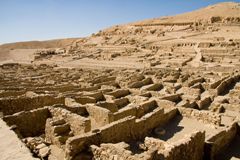
Amarna gives us our best and fullest look at an ancient Egyptian city. Lying partly outside the farming zone, its remains are accessible, not buried under meters of silt. In addition, the city was occupied for a short time only, during the final eleven years of the reign of Akhetaten and a few years after. The site was abandoned when the capital returned to Thebes, never to be rebuilt. Taking advantage of these propitious conditions, archaeologists have extensively explored the city since the late nineteenth century. The city plan is clear. A city center contains government offices, the main temples, storerooms, and the great palace, placed alongside the main street, the Royal Road. The Royal Road, parallel to the river, continues to outlying residential districts. Excellent examples of private houses of the well-to-do have been discovered, typically a modest-sized but comfortable house inside a walled compound, with gardens, work areas, servants' quarters, and a chapel to the Aten.

Bronze Age shipwrecks
Some idea of Late Bronze Age ships and the international character of trade comes from two wrecks found off Turkey's south-west coast. The earlier and larger of the two was discovered at Uluburun, near Kaş. Dated to the late fourteenth century BC, this ship, ca. 17m long, contained a varied cargo. Included were ten tons of copper and one ton of tin, all in ingot form; bun-shaped glass ingots; other raw materials, such as terebinth resin, used for incense and perfume, African black logs, and elephant and hippopotamus ivory; Cypriot and Mycenaean pottery; a gold scarab inscribed with the name of Nefertiti, Akhenaten's wife; and food of various sorts.
The wreck found off Cape Gelidonya is smaller (10m long) and later (ca. 1220 BC). It, too, was carrying a cargo of metal: copper oxhide ingots from Cyprus, scrap bronze tools also from Cyprus, and tin ingots. The remainder of its cargo was not as varied as that of the Uluburun wreck. Nonetheless, even if the nationality of either the maker or the owner is uncertain, the cargoes of both ships suggest they were sailing westward from the Levant or Cyprus to the Aegean.

Ramses II and Abu Simbel
Reigning for 67 years (1279-1213 BC) in the Nineteenth Dynasty, Ramses II emphasized his status through a series of grandiose building projects. Additions to the Temples of Amun at Luxor and Karnak have already been noted elsewhere. Built completely by Ramses II is the temple at Abu Simbel alongside the Nile in the Nubian frontier zone. The façade is spectacularly decorated with four colossal seated statues of the king himself. The hierarchy of power is clear. The accompanying figures of his wives and children are tiny; even the image of the god, Re-Harakhte, although centrally placed over the entrance, is much smaller.

Yazılıkaya
This shrine lies 2km north-east of Hattusa. Built in the thirteenth century BC in honor of the weather god, it consists of open air chambers originally concealed by a series of buildings in front (now preserved only in foundation). Relief sculptures decorate the two principal chambers. In the main chamber, male gods on the left and goddesses on the right process toward the rear of the chamber, where the great weather god greets his wife, the sun goddess of Arinna. Inscriptions give their names: Teshub and Hepat. Elsewhere, in this chamber and in the main side chamber, reliefs have been added of the king, Tudhaliya IV, in the protecting embrace of the god Sharruma.

Fall of Bronze Age Anatolia
Hattusa was attacked and destroyed ca. 1200 BC, part of the wave of violence, disruption, and change that afflicted the larger Aegean and eastern Mediterranean region at this time. In the centuries ahead, the Hittites would be replaced as rulers in central Anatolia by the Phrygians, from their capital at Gordion.

Phoenician ships and ports
Ships, shipping, and harbors were an essential part of Phoenician city life. Evidence for ships comes from pictorial imagery and from shipwrecks. Assyrian reliefs show, for example, the "hippos" ("horse"), a small commercial boat with a horse-headed prow. Warships are illustrated on coins issued by Sidon, Byblos, and Arwad, beginning in the mid fifth century BC. A well-studied example of a Phoenician harbor is found at Atlit, south of Haifa. Taking advantage of a promontory, the Phoenicians built a sheltered harbor on its north side. Offshore islets constituted the west side; two moles carefully constructed from the seabed up form the north and east arms.

Fall of Mycenaean civilization
During the twelfth century BC, the palace-based system of Mycenaean political and economic organization came to an end. Destructions, abandonments, shifts in settlement, and other evidence of unrest mark the end of an era, as elsewhere in Anatolia and the eastern Mediterranean. The causes of these changes, whether natural or human, or both, continue to be debated. The Aegean basin reverted to a village-based economy, with little external trade and few luxuries.

The Greek Iron Age
The twelfth through the ninth centuries BC are often called the Greek Dark Ages, the village-based era that followed the collapse of the Mycenaean palace system. But "dark" conveys cultural regression; the neutral term "Iron Age," denoting a chronological period, is now preferred.

Iron Age migrations
Ancient writers chronicled two major movements of peoples during the Greek Iron Age. The first is the so-called Dorian Invasion, a southward migration from the Balkans of speakers of the Dorian dialect of Greek. The second, beginning in the eleventh century BC, is the migration of Greeks eastwards across the Aegean to the Anatolian coast and the islands offshore. The Dorian Invasion has been difficult to observe in the archaeological record; in contrast, the migration to East Greece has been confirmed by ceramic finds. In a third movement, from the mid eighth to the later sixth centuries, various Greek cities sent colonizing missions to distant shores, notably to South Italy and Sicily in the west, and to the Black Sea and its approaches in the north. The motives for founding these new cities included relief of population pressure, the search for arable land, and escape from political conflict.

The rise of the polis
The reasons for the rise of the polis in the Greek Iron Age are controversial. Villages may have coalesced to promote a particular local cult, as in Sumer, or because of specific economic benefits. Some early towns originated as fortified centers in defensible locations. Coastal settlements often lay on promontories, such as Smyrna, or on hilltops, such as Lefkandi and Zagora. The polis included both an urban center and the rural hinterland. The sizes of city-states varied enormously, from small to huge. Syracuse, on Sicily, was one of the largest, in both territory and population. The system of government varied, too; kings, aristocrats, or, in some cases such as Athens, the entire male citizenry might wield power. Women were excluded from political life, as were foreigners, indentured servants and farmers, and the many slaves.

The Greek sanctuary
In ancient Greece, the temple (the home of the deity) and the outdoor altar (where people worshipped, with sacrifices and other offerings) were the main elements in a sacred area, often marked by a low wall: the sanctuary, or temenos. A well-known example of an Iron Age sanctuary is the Heraion on Samos.

The Heraion on Samos
The site was active in the Bronze Age and would continue so throughout antiquity, but the remains from the Iron Age period are particularly instructive. The altar is the earliest feature attested, joined soon after by the long, narrow Temple of Hera. Both would be remodeled several times during this period. By the seventh century BC, the sanctuary also contained a propylon (a formal gateway), a stoa (a porticoed shelter), and a stone-lined basin for bathing the cult image.

Phoenician fortifications
Little has survived from Tyre's Iron Age past. Architecture from the twelfth to seventh centuries BC is better known from other sites, notably Tell Dor on the Israeli coast. The best evidence for fortifications comes from downtown Beirut, from excavations carried out after the Lebanese Civil War of 1975-1990.

Neo-Assyrian cities
The long history of Assyria, today's northern Iraq and north-east Syria, to a large extent connects with that of the south, traced in Chapters 2 and 3 of Ancient Cities. In the Iron Age, the tenth to seventh centuries BC, the resurgent Assyrian kingdom dominated much of the Near East. In chapter 10, you can find discussion of three of its capital cities, Kalhu, Dur-Sharrukin, and Nineveh, to see how they illustrate essential features of Assyrian architectural planning and decoration.

Anatolia and the Levant
This section in chapter 10 of Ancient Cities briefly presents the Phrygians, dominant in central Anatolia during the Iron Age, with their capital at Gordion; the Urartians, in eastern Anatolia; the Philistines, in the southern Levant, based in five cities; and Jerusalem, capital of Israel. In Jerusalem, Solomon (ruled ca. 965-931 BC) built a magnificent temple, with the significant contribution of Phoenician artisans and materials. Although destroyed by the Babylonians in 586 BC, the thorough description in the Bible allows a detailed reconstruction.

Tyre and the Phoenicians
The Phoenicians, Iron Age successors of the Bronze Age Canaanites in the central Levant, were never politically unified; instead, they were organized as independent city-states. Tyre and Arwad were located on offshore islands; others, such as Byblos, Beirut, and Sidon, were located on promontories. Of these cities, Tyre was preeminent from the tenth to the mid sixth centuries BC, Sidon from the sixth through the fourth centuries BC. Hiram I (ruled 969-936 BC), Tyre's first great king, was instrumental in the early development of the city. He joined two adjacent islands into one, added fortifications, developed the natural harbor on the north (the "Sidonian harbor"), and rebuilt the temples to the city's three main gods: Melqart ("Lord of the City"), Astarte, and Baal. In the ninth century BC, a second harbor was added on the south, the "Egyptian harbor." The mainland suburb of Ushu supplied the island center with water, agricultural products, and fuel. Also on the mainland were the cemeteries.
The topography of Tyre changed forever when Alexander the Great, during his siege of the city, built a mole connecting the mainland with the island.

Tyre in the east Mediterranean
Tyre's expansion began with a commercial and cultural agreement between Hiram I (ruled 969-936 BC) and Solomon, king of Israel. Phoenician craftsmen assisted in the construction and decoration of the Hebrew temple in Jerusalem, and together, Phoenicians and Israelites undertook sea journeys down the Red Sea in search of exotic and precious materials. Subsequent expansion was directed toward Cyprus and Cilicia. The discovery at Karatepe, a citadel in the Cilician foothills, of a long text in both Phoenician and hieroglyphic Luvian (a language related to Hittite), dated to the late eighth century BC, indicates the prestige enjoyed by the Phoenicians in this region.

Greek cemeteries - Lefkandi
Information about the Greek Iron Age also comes from cemeteries, such as the well-known examples at Lefkandi and Athens. The Toumba cemetery at Lefkandi has yielded a remarkable burial from the mid tenth century BC. Two adjacent compartments under the floor of a long, narrow building served as graves, the first for a man and a woman, both anonymous, the second for four horses. The man was cremated, his ashes placed in a bronze krater that originated in Late Bronze Age Cyprus. The woman, in contrast, was not cremated; her skeleton was covered with gold jewelry. The grave offerings and the large building, both imposing for the period, indicate the high status of the deceased. Moreover, the building was found partially dismantled and covered with a tumulus, another mark of respect. Burials continued to be made beside the building until ca. 825 BC.

Kalhu (Nimrud), Assyria
Located on the east bank of the Tigris River, Kalhu was developed as the new capital by Assurnasirpal II (ruled 883-859 BC). The city demonstrates several features characteristic of Assyrian Iron Age cities. First, the city was laid out in a rough rectangle and enclosed by a mud brick fortification wall. The area enclosed was immense: 360ha. Second, the city contained two separately walled citadels, each raised above the rest of the city on an artificial platform made of bricks and located at the edges of the city, not in its center. The first, located in the south-west, was constructed on top of the mound composed of earlier occupation; this citadel was the site of the palaces and temples. The second citadel, in the south-east, was devoted to military activities. Known as Fort Shalmaneser, it was built by Shalmaneser III (ruled 858-824 BC), the son of Assurnasirpal II.

The Northwest Palace, Kalhu
This large Assyrian palace at Kalhu, divided into two sections, one public (north), one private (south), consisted of several courts with rooms arranged around them. Notable was the long, narrow throne room, with doorways guarded by lamassu, colossal relief sculptures of a human-headed winged bull, a magical creature that protected the king from danger. The throne room and other rooms nearby were decorated with orthostats, stone slabs placed upright against the lowest sections of the walls and carved with scenes that glorified the king: victorious in battle, successful in the hunt, and piously offering libations to the main god of the state, Assur.

Phoenician religious centers
Surviving examples of temples and sanctuaries from the Phoenician heartland are few. Kition, a Phoenician city on nearby Cyprus, has yielded remains of a covered temple of ca. 850-400 BC, with a courtyard, a main building with covered aisles and an open-air central nave, and a small rectangular room at the end, perpendicular to the nave, that served as the holy of holies. Two upright ashlar blocks flanked its entrance. Two sanctuary complexes that lie outside the city have been excavated at Amrit (near Arwad) and north-east of Sidon. Both were developed in the Persian period, from the mid sixth century BC on; both were dedicated to the healing god, Eshmun. Water was important at both sanctuaries, coming via streams. At Amrit, the stream was channeled into the central court, creating a sort of sacred lake. The images of the deities seem to have been aniconic (non-figural). At Amrit, the central shrine is now empty, but at the Temple of Eshmun near Sidon, a "throne of Astarte," an empty stone throne flanked by sphinxes, was discovered in a chapel to that goddess, an aniconic image of this deity frequently used in Phoenicia.

Phoenicians in the west
In the eighth century BC, the Assyrians cemented their control over Phoenicia. Although the cities retained much autonomy, the Assyrians appreciating their maritime and commercial skills, the Tyrians, in particular, felt the need to establish their presence freely in lands beyond the reach of their Assyrian overlords. In the late ninth century BC, according to ancient tradition, Tyrians founded Kition, on Cyprus, and Carthage ("Qart-hadasht", "New City"), on the Tunisian coast. Archaeological evidence confirms Phoenician settlement in the central and western Mediterranean beginning at a somewhat later date, from the mid eighth century BC on. The towns established on Sicily, Sardinia, Ibiza, and in the coastal areas of southern Spain were intended primarily as trading posts, centers for the obtaining and shipping of raw materials. Such motives differed from those of the Greeks, expanding into the central Mediterranean at the same time; the Greeks sought farmland, for agriculture-based colonies.

Carthage
The greatest of the Phoenician settlements in the central Mediterranean, Carthage grew prosperous from agriculture, its African trade, and its commercial interests in the western Mediterranean. These last increased from the sixth century BC on, after the Babylonian conquest of Tyre and Phoenicia in the early sixth century BC dealt a serious blow to the direct connections between the Phoenician heartland and its outlying areas. The Carthaginians would come into conflict with others in the region, however, first the Greeks, based in Sicily and south Italy, then the Romans. Disputes with the Romans culminated in the three Punic Wars (264-146 BC) with, at the end, the Roman capture of Carthage and the destruction of the city.
Evidence for the Punic period at Carthage is sporadic, because of first, the Roman destruction and, second, later rebuilding on the site, the result of the Roman refounding of Carthage as a major North African urban center in 29 BC. The earliest datable archaeological evidence is imported Greek pottery from the mid eighth to the early seventh centuries BC, discovered in three cemeteries on and near the Byrsa Hill, the center of Punic Carthage, and the Salammbo sanctuary area, near the harbors. The presence of such pottery indicates the international character of the city's contacts, even in its earliest phase. Also starting early is the tophet; from ca. 700 BC, this special sanctuary and burial ground was used for child sacrifice, a practice the Carthaginians continued long after it was abandoned in the Levant. Evidence for settlement, at least on the Byrsa Hill, does not begin until the fourth century BC.

Gadir
A prime example of a Phoenician trading settlement in southern Spain, Gadir (modern Cadiz) was located on small offshore islands with convenient access, via nearby rivers, to the rich Aznalcollar and Rio Tinto mining areas.

The Etruscans
The Etruscans were the major Iron Age people of the central Italian peninsula, flourishing in Etruria, north of Rome, from the eighth century BC. Their origins have been the subject of controversy, even in antiquity: indigenous or immigrants? Archaeological evidence suggests a compromise view, that they were a native Italic people but strongly penetrated by foreign influences during the formative centuries of their culture. Their history is known especially through the Romans, for surviving texts in their own, imperfectly understood language are short. The Etruscans were organized politically in independent city-states, ruled by kings and aristocrats. They extended their control north into the Po River valley and south to Latium and Campania, even ruling Rome from ca. 600 to 509 BC. From the fifth century BC their power declined, the result of defeats at the hands of Syracuse, raiding Gauls, Italic Umbro-Sabellian tribes and, eventually, the Romans.

Etruscan cities
Although Etruscan cities have been poorly preserved, often lying beneath later settlement, certain characteristics are known. In southern Etruria, defensible bluffs and hilltops were preferred locations. The grid plan was favored, even if irregular topography often necessitated modifications. Roman writers recorded the Etruscan ritual for laying out a new city, a practice taken over by the Romans. Considered as a sacred territory, the city was demarcated by a furrow created by a bull and a cow harnessed to a plough. At gateways, the plough was carried over the ground, thus creating breaks in the sacred circle through which people and animals could pass.

Etruscan tombs
Tombs have been a major source of information about Etruscan culture. Like the Egyptians, the Etruscans devoted much attention to preparations for death and the afterlife. In early centuries, cremation was the norm. Ashes were stored in an urn, either metal or ceramic, placed in a tomb. Urns came in different forms, including as an imitation of a simple house. A more complex container is a terracotta sarcophagus from Caere, ca. 525 BC (Figure 19.13). A couple recline on a banquet couch, an invocation of daily life customs, the funerary banquet, and/or meals in the afterlife. Inhumation became the norm in southern Etruria, from the fifth century BC on. Tombs were underground, either built of masonry or carved from the rock; sometimes a tumulus might be constructed on top of a cluster of tombs. Tomb interiors resembled houses, with rooms with pitched roofs and other construction details carefully indicated. Ground plans were varied. Walls might be painted with a variety of figural scenes, good evidence for religion and ritual as well as daily life. Etruscan mythology, often depicted, recalls Greek and Roman mythology, but with differences, for the Etruscans had their own traditions. A few tombs have decorations that are carved from the stone, not painted, such as the Tomb of the Shields and Chairs, from Caere. Among the many types of grave offerings recovered from Etruscan tombs, Attic pottery deserves mention as a distinctive favorite. Indeed, thanks to the Etruscans, Etruria has been a much more fertile source of complete black-figure and red-figure vases than Athens itself.

Olympia: the Sanctuary of Zeus
Like Delphi, Olympia was a Panhellenic sanctuary, that is, attracting visitors from the entire Greek world, from the eighth century BC (the Greeks believed the Olympic Games began in 776 BC) through Roman antiquity. The sanctuary lies in a flat, fertile, wooded plain in the north-west Peloponnesus, 12km from the sea. Zeus and Hera were the main gods worshipped here, in two large temples; in between the temples lay the focal point of ritual at the sanctuary, the main altar – made of ash, not the usual stone.

Olympic Games and athletics
The Greeks began their calendrical reckoning with the first Olympic games, which they dated to 776 BC. The facilities for the games lay just outside the sanctuary. They are surprisingly simple to the modern observer: a stadium almost 200m long, for foot races and other events, with a hippodrome for chariot races located elsewhere. The games were held every four years in late summer. City-states agreed to a one-month truce in order that they take place; over the long history of the games this truce was rarely broken. Since the games were offered in the religious context of Olympia, the festival began with prayers, sacrifices, and the swearing of an oath of fair play. The events varied throughout the centuries, but included foot races; a special foot race with contestants wearing armor; boxing; wrestling; throws of the discus and javelin; and chariot races. Practices were different from today; for example, boxers' hands were lightly padded, and competitors of most events were naked, one of a handful of arcane regulations perhaps relating to the sacred origins of the games. Contestants were male citizens. A separate athletic festival for women was held at Olympia every four years, the Heraia, in honor of the goddess Hera; the only event was a foot race. At first amateurs, by the Roman imperial period contestants tended to be professional athletes, who earned their living competing at a large circuit of festivals. Because of their association with the pagan gods, the Olympic games, like other pagan festivals, were abolished in AD 393 by order of the emperor Theodosius I.

Geography of Rome
The city of Rome lies at a fording point on the Tiber River some 24km inland from the Mediterranean, at a junction of roads leading both north-south and east-west. The spot is hilly, with streams in the valleys between the hills.

Early Rome, ca. 753-509 BC
Rome was founded on 21 April, 753 BC, according to tradition, by Romulus and his twin brother Remus. The first settlement was on the Palatine Hill: simple one-room houses, with walls made of wattle-and-daub and vertical poles supporting a thatched roof. The swampy land to the north of the Palatine Hill served as a burial ground, particularly for cremations.
During the sixth century BC, Etruscan kings ruled the city. The Etruscans drained the swamps and channeled the streams that fed them, with special attention devoted to the area north of the Palatine that would eventually become the city center, the Forum Romanum. On the nearby Capitoline Hill, the Etruscans built their citadel and their principal temple, dedicated to the god Jupiter (as the Romans would call him). The scanty remains of this early temple indicate it had three cellas in the typical Etruscan fashion, with Jupiter housed in the center, Juno and Minerva to the sides.

Zagora, Greece
Zagora was a small Iron Age town on the island of Andros, located on a bluff above the sea. The site was picked because it could be protected. Architecture was modest: simple one-storeyed houses. The town was inhabited in the eighth century BC; afterwards, as the danger from marauders receded, the practical difficulties of daily life in a remote place without easily available water encouraged people to move elsewhere. The discovery in central Zagora of a temple dated to the sixth century BC, after the abandonment of the town, testifies to the maintaining of old cults and sacred places.

Athens: the Kerameikos
The Kerameikos cemetery lay just outside the Dipylon Gate on the north-west edge of Athens. Long used, from the Late Bronze Age to the Roman Empire, this cemetery contained striking burials from the eighth century BC. Wealthy cremation graves would be marked with a large pot, a krater or an amphora, up to 1.75m in height, elaborately decorated with bands of geometric motifs and, sometimes, figural scenes rendered in the Geometric style particular to the period.

Votives, writing, and coinage
Worshippers in the Iron Age and later periods routinely left offerings in sanctuaries, modest (figurines, for example) or rich (such as life-size statues). The bronze figurine offered to Apollo by Mantiklos, ca. 700 BC, is a fine example (see Fig 12.10 in Ancient Cities). Its style is Geometric; it bears an inscription, an early example of writing in the Greek alphabet, in boustrophedon form (lines of words written in alternating directions) – the dedication to the god. The alphabet was adapted from the Phoenician alphabet by the mid eighth century BC, but where, how, and by whom is unknown. Another borrowing from the Near East, coinage, comes later. Coins were first used by the Lydians, a non-Greek people of western Anatolia, in the late seventh century BC. The sixth century BC saw the invention spread quickly to their Greek neighbors and thence to the entire Greek world.
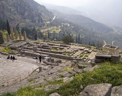
Delphi: the Sanctuary of Apollo
Delphi, like Olympia, was a major religious center throughout Classical antiquity, with special importance from the eighth to the late fourth century BC. Dramatically sited on steeply sloping ground below cliffs, Delphi comprised two sanctuaries. The larger and more famous was dedicated to Apollo, the smaller to Athena Pronaia (not examined in this book). A village adjacent to the sacred areas housed those who maintained the sanctuaries and catered to pilgrims and tourists; it had no political importance.

The Delphic oracle
The Pythia at Delphi answered specific questions; she did not predict the future in general. Answers might be cleverly ambiguous, applicable to any outcome. Some answers were recorded by ancient authors. Those attributed to the early years, ca. 750-450 BC, are considered later fabrications, created to suit the reputation the Greeks had of the oracle; these replies should be treated with caution. Nonetheless, the patterns of questions and answers are instructive. City governments as well as individuals could consult the oracle. Advice and blessings were routinely sought by groups of early colonists before they set off, ensuring the oracle's key role in the foundation of new cities.

Commemorative monuments
In addition to buildings, a sanctuary contained countless objects offered in thanks for a great range of successful outcomes. Donors at Delphi included individuals, but also governments. Among the monuments offered by city-states are items that celebrated the fruits of cooperation, notably the victories in the Persian Wars. But one also saw monuments to inter-city rivalry, trophies proclaiming the military triumph of one city-state over another. Monuments given by individuals include the Charioteer of Delphi (Fig 15.5 in Ancient Cities), a bronze statue originally part of a larger sculptural group consisting of a chariot drawn by four horses with a groom in attendance. This monument was dedicated by Polyzalos, tyrant of Gela, a Greek city in Sicily, to commemorate his victory in a chariot race at Delphi in either 478 or 474 BC. Polyzalos was not himself the winning charioteer, but the sponsor of the team – but sponsorship sufficed to collect the prize.

Greek cities in Italy
Beginning in the mid eighth century BC, certain Greek city-states founded colonies in the coastal regions of southern Italy and Sicily. The reasons for these foundations included relief of overpopulation and the desire for fresh agricultural land, and an outlet for political dissidents. These new cities became completely independent from their mother cities, although relations normally remained strong. This distinct region of the Greek world is known as West Greece or by its Latin designation, Magna Graecia.

Syracuse
The most important city on Sicily during Greek and Roman antiquity, Syracuse was founded by Corinthians in the later eighth century BC. Original settlement was on a small island, but eventually spread to the nearby mainland; by the mid sixth century BC, the island was linked to the mainland by an artificial causeway. In the early fourth century BC, Dionysios I expanded eightfold the fortified area of Syracuse, with the complex Euryalus Fort built at its western apex. In population, the city was one of the largest in the entire Greek world. The Romans captured it in 212 BC, the final step in their conquest of the Greek cities of South Italy and Sicily. The typical form of government at Syracuse, as elsewhere on Sicily, was tyranny, not democracy. Such rulers had the opportunity to affect the appearance and working of the city. Their counterparts in other cultures and periods might promote themselves through art and architecture, but at Syracuse, this was not necessarily the case. For example, Dionysios I, himself a writer of tragedies, patronized poets and writers. More traditional was Hieron II, a long-ruling tyrant from the third century BC. He commissioned an immense free-standing altar and the remodeling of the theater. In addition, he and his wife were the first rulers depicted on the city's coins, a practice common in the Hellenistic east.

Corinth: Orientalizing pottery
Ceramics have been important for the study of Greek cities. They have contributed to chronology, to studies of economy and trade, and, when decorated with figural scenes, to knowledge of daily life and religious practices. Corinth, an active trading center in the later Iron Age, produced pottery of distinctive shape and decoration in the late eighth and seventh centuries BC. Small shapes such as the aryballos were used to export perfumed oil. Figural decoration was influenced by Near Eastern art in its love for animals, both real and imaginary. Occasionally hoplite warriors are shown, reminders of changes in warfare that occurred during this period when armed conflict between cities became a regular part of ancient Greek life.

Hoplite warfare
Pictorial depictions from the Orientalizing period occasionally reflect the move towards hoplite warfare seen in this period. The hoplite was a citizen infantryman, armed with helmet, shield, and spear. The phalanx formation, lines of hoplites standing close together so their shield would give some protection to the man to the left, proved to be effective for both attack and defense.

Dur-Sharrukin, Assyria
Sargon II (ruled 721-705 BC) founded this Assyrian city as his new capital. Its life was short, for it was abandoned after Sargon's death, his successors preferring Nineveh. The plan of the city conforms to the norms established at Kalhu in the previous century. Here, too, a large area (nearly 300ha) was surrounded by a fortification wall, and furnished with two citadels, protected by their own walls. The southern citadel was the Imperial Arsenal, the military center. The citadel in the north-west contained the royal palace and temples, arranged in haphazard fashion – a lack of overall planning odd for a complex erected at one time. The palace was built on a special platform. Its architecture and decoration resembles that of the Northwest Palace of Assurnasirpal II at Kalhu.
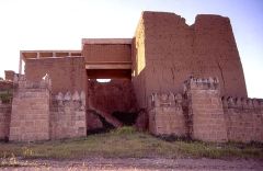
Nineveh, Assyria
A city of long habitation located on the east bank of the Tigris, Nineveh was the final capital of the Assyrians, in the seventh century BC. Its walls enclosed an extremely large area, 750ha. Like Kalhu and Dur-Sharrukin, Nineveh contained a citadel with palaces (here called Kuyunjik) and a second mound (Nebi Yunus), the arsenal. A third mound, the "old city mound" in the north-west, was not remodeled by the rulers, but was an upper-class residential district. The palaces from Kuyunjik, explored in the nineteenth century, have yielded numerous orthostats with scenes of military victories and triumphant lion hunts.

The Temple of Apollo, Delphi
The Sanctuary of Apollo at Delphi, a large rectangle crammed with buildings and monuments, is dominated by the Temple of Apollo and the Sacred Way that zigzags up to it. The Greeks, fond of consulting oracles for advice about the future, came to the temple to consult Apollo, the oracular god. The vehicle for prophecy was a middle-aged woman, the Pythia, through whom Apollo was believed to speak.
Three certain versions of the temple have been discovered. The earliest, perhaps from the mid seventh century BC, burned in 548 BC. This was replaced by a large Doric temple, completed in 506 BC but destroyed in an earthquake in 373 BC. The third version reproduced the plan of the second. Because of the special needs of the cult, this temple contained an extra room, an adyton or inner sanctuary, located behind the usual cella but at a slightly lower level, over a cleft in the bedrock. Here the Pythia sat on a tripod, Apollo's sacred seat, in order to receive the divine inspiration.

Early Doric temples
The Doric order seems the result of architectural developments in Corinth and environs during the seventh century BC. Certain early temples in other parts of Greece document the process of development in the early Archaic period. At the Temple of Apollo at Thermon, ca. 630 BC, surviving terracotta metope plaques testify to an early use of the Doric triglyph-and-metope frieze and a solution of the vexing problem of how to align the corner column with the corner of the entablature above. Another solution to the Doric corner problem was tried at the Temple of Hera at Olympia, ca. 600 BC: bringing the corner column in, closer to the adjacent column. The columns of this temple were originally wooden, set on stone foundations. Over the centuries, the columns were replaced by stone versions. The final example presented, the Temple of Artemis at Kerkyra (Corfu), also ca. 600 BC, offers two additional features that would become distinctive of Greek religious architecture. The ground plan of this large temple is the first known example of a pseudo-dipteral colonnade: space was allowed for two rows of columns around the temple rooms, but only the outer row was actually built. The second important feature consists of well-preserved sculptures from the west pediment, an early example of the decorated pediment. A huge figure of the Gordon Medusa occupied the center. She is flanked by lions and, in the far corners, on a far smaller scale, tiny figures in scenes of violence. Only in later decades would sculptors create an entire pedimental scene with a unified scale and theme.
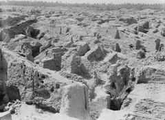
Babylon
The best documented period of this long-inhabited city is the mid Iron Age, late seventh century BC to 539 BC, when it was the monumental capital of a kingdom controlling central and southern Mesopotamia. Evidence comes from archaeological exploration and textual evidence, notably the description written by the Greek historian, Herodotus. The extended city was immense (850ha), the inner city itself large (400ha). Both sections were fortified. The inner city consisted of a rectangle that straddled the Euphrates. The city was organized on a grid plan, unusual for the continually evolving cities of central and southern Mesopotamia. Tablets give some names of streets, neighborhoods, cult places, and other topographical features. Unlike the Assyrian cities to the north, such as Nineveh, Kalhu and Dur-Sharrukin, Babylon restored the main religious buildings to a place of honor in the center of the city. The palaces, grand though they are, are located apart, at the edges of the inner city. Both temples and palaces are located on the same ground level as the rest of the city, another contrast with Assyrian practice.

Temple of Marduk, Babylon
A processional way led from the Ishtar Gate in the north of Babylon to the Temple of Marduk and ziggurat in the center. The Ishtar Gate was decorated with protecting creatures: dragons (the symbol of Marduk), bulls (the symbol of the god Adad), and lions, all made with colored glazed bricks, sometimes flat, sometimes in relief, set against a bright blue background. The ziggurat survived only in foundations, ca. 91m2, but was described by Herodotus as an eight-stepped tower with, on top, a small temple with a couch where Marduk would sleep. The great Temple of Marduk also survived poorly; dimensions were recovered, but few details of the interior plan.

The Southern Palace, Babylon
Resembling Assyrian palaces, the large Southern Palace of Nebuchadrezzar (ruled 604-562 BC) in Babylon consisted of public and private rooms grouped around courtyards. The long rectangular throne room was entered through three doors on its long side. In contrast with Assyrian practice, this palace was not decorated with orthostats or protected with lamassu. Instead, fine wood, bronze and gold trim, and occasional glazed bricks with geometric patterns, trees, and animals made the rooms elegant. A puzzling cluster of 14 vaulted storerooms with adjacent shafts, perhaps for the hauling of buckets by chains, may be the substructures of the celebrated Hanging Gardens, a lavish penthouse garden built, according to the local third-century BC historian, Berossus, to satisfy the longings of Nebuchadrezzar's wife for the forests of her northern homeland.

Paestum (Poseidonia)
Poseidonia, better known by its later Roman name, Paestum, is the best known of the Greek colonies on the Italian peninsula, thanks to its three extremely well-preserved temples and the exceptional paintings that decorate an otherwise simple tomb, the Tomb of the Diver (ca. 480 BC). The city was founded ca. 600 BC by migrants from Sybaris, a south Italian Greek colony. A fortification wall with four gates enclosed the town, perhaps laid out on a grid – the type of plan established by the Romans after they absorbed the city in 273 BC. If a grid was used, it would have differed from the Roman, for the three temples and the north and south city gates, all Greek, do not conform to the Roman alignments.
The three great temples conform to the traditions of Greek architecture even as they display design variants characteristic of West Greek practice. In order of construction, they are: the Temple of Hera I (ca. 550 BC), the Temple of Athena (ca. 500 BC), and the Temple of Hera II (ca. 470-460 BC). All are Doric, the order preferred in West Greece. All are built of local stones, travertine and sandstone, for marble was lacking in this region. Design could be innovative, not simply derivative from the Greek heartland, as the early use of architectural refinements indicates. Certain features, such as entasis (the convex bowing of column shafts), were often used in West Greek architecture, whereas others, such as the curvature of the stylobate, were rare.

Archaic Sparta
Sparta had a social system unique in the ancient Greek world, developed during the seventh century BC. Male citizens devoted their lives to military training. Economic support was provided by conquered peoples (also Greek) of the southern Peloponnesian regions of Laconia and Messenia. Daily life was austere. Group solidarity was important; individuality was discouraged. The aim was to create a hoplite army that would be second to none. Indeed, until a stunning defeat in 371 BC, Sparta fielded the finest infantry in the Greek world. It should come as no surprise, then, that the city has left little of architectural interest from the Archaic and Classical periods. Indeed Thucydides, the historian of the Peloponnesian War, contrasting Sparta with Athens, remarked that buildings alone do not indicate a city's greatness. No one would ever guess that Sparta, dull and simple in appearance, was the equal in power and prestige of Athens with its magnificent art and architecture.

Athens in the Archaic period
Athenian writers, in contrast to the lack of Spartan evidence about their own culture, have left a rich record of information about their city's society and history. Political developments in Athens took a different turn, leading from the domination of aristocrats to a democracy in which all male citizens had an equal voice. These developments, often turbulent, happened over a period of 150 years, from the late seventh into the fifth century BC.
In architecture and art, Athenian achievements were seminal. Although Athens is best known for its fifth-century BC buildings, much remains from the Archaic period. The Acropolis, the largest hill in the central city, was turning from an earlier role as a fortified citadel into a major religious sanctuary, the home of Athena, the patron goddess of the city. Not far away, a smaller hill, the Pnyx, was the place where the Popular Assembly held its meetings. The lower ground to the north-west of the Acropolis, earlier used for housing and for burials, was established as the Agora, the civic center, in the early sixth century BC. The area, formally marked with boundary stones, contained buildings devoted to city government, a law court, shrines, and a fountain house. The Panathenaic Way, the processional route to the Acropolis used during the Panathenaia, the annual festival to Athena, crossed the Agora on the diagonal. By 400 BC the most important civic buildings were in place. With many changes in its architecture and monuments, the area would continue as a civic center through the Roman Empire, to be gradually abandoned and covered over during the Middle Ages.

Archaic Greek art
The pottery and sculpture made by the ancient Greeks have had a major impact on our understanding of their world. The figural imagery painted on pots and carved in sculpture has given invaluable illustrations of Greek people and animals, real, legendary, and divine, and the world, natural and built, within which they lived.

Black- and red-figure pottery
The Greeks considered pottery making a craft, not a high art. Esteemed instead was the painting of great narrative panels hung on the walls of public buildings. But the panel paintings have all disappeared, whereas pottery survives well in archaeological contexts. The Etruscan habit of included imported Attic (= Athenian) vases among their grave offerings has ensured that many complete pots exist today.
The leading producer of decorated pottery in the Archaic and Classical periods was Athens. Two main techniques were used, black-figure and red-figure, with a third, white-ground (painting on a white background), added in the fifth century BC. Black-figure developed smoothly from previous seventh century BC techniques. Figures were black, whereas the background was the natural orange-red color of the clay of Attica. Red-figure, the opposite, with figures left orange-red, the background covered with black, was developed ca. 530 BC as a complement to black-figure. In both cases, the effects of red and black colors were creating during the firing process, the result of chemical reactions caused by the manipulation of the air (oxygen) supply.
Subjects of figural scenes favored mythology and daily life. The wish to illustrate stories more effectively may have been a factor in the increasing interest in showing more realistic three-dimensional motion. Portraits of specific people were rare; absent were images of current events and leaders – political, military, or other – of the city.

Archaic sculpture
Life-sized and even larger sculpture in stone developed in the later seventh century BC, with influence from Egyptian sculptural practice. Popular types in the Archaic period included the kouros and kore, statues of young men and women, made as prestigious dedications to the gods. These were not portraits, but generalized images of youths in their physical prime. The kouros (the male figure) was nude, a culturally accepted feature probably related to the practice of competing naked in the athletic contests that originated in religious festivals. The kore (female figure), in contrast, was clothed. Both were painted to a large extent, but the paint has generally disappeared over the centuries. By the mid-to-late sixth century BC, bronze joined stone as a material for life-sized statues; such statues would be hollow cast. The use of bronze allowed a greater variety of movements to be shown. Most bronze statues have disappeared, however, melted down for other purposes.

Archaic East Greece
Ancient writers make clear that the cities of the east Aegean were at the forefront of Greek civilization during the Archaic period, even after they were conquered by the Persians in the 540s BC. Miletus was particularly prominent. A coastal city, Miletus grew prosperous from maritime trade. It founded some 90 colonies, especially in the Black Sea region. Its citizens included important pioneers in philosophy and science. Remains of the period are scarce, however, because of rebuilding in the Hellenistic and Roman imperial periods. A smaller yet striking example of an Archaic city from East Greece is provided by Samos, the ancient capital of the island of the same name, 6.5km east of the Heraion. During the rule of the tyrant Polykrates (538-522 BC), a prosperous period, the city was enhanced with new buildings. The overall layout can be appreciated, thanks to the fortification walls that still enclose a coastal location with a harbor and an acropolis. The most remarkable construction is the Tunnel of Eupalinos, a 1km-long tunnel bored through the mountain behind the city, one part of an aqueduct that brought water from an inland spring.

The Doric and Ionic orders
As in most civilizations we have examined, the Greeks reserved the finest materials and workmanship for religious buildings. If people's houses remained modest during the Archaic and Classical periods, temples, the homes of the gods, received the best. Both materials and design changed in the early Archaic period. Stone gradually replaced mud brick and wood, surely inspired by Greek admiration for Egyptian stonework. Details of form and decoration, conservatively deployed in a narrow range of proportional relationships, coalesced into two systems of design, the Doric and Ionic orders. The Doric order developed on the Greek mainland in the late seventh century BC, whereas the Ionic order emerged some 25 years later, in East Greece. The origin of the decorative details is uncertain. Translation into stone of construction details of earlier wooden and mud brick architecture is an attractive explanation, but remains unproven.
The two orders are similar, following the same basic principles for foundations, ground plan, and elevation. For details, the reader should consult chapter 13 of Ancient Cities. Notable differences between the two orders occur in the absence or presence of a column base, the form of the column capital, and the treatment of the entablature (both the architrave and the frieze).

Early Ionic temples
The Ionic order developed in East Greece, with the earliest examples from the second quarter of the sixth century BC. At the Heraion on Samos, architects Rhoikos and Theodoros built the third major Temple to Hera above the seventh-century temple (described in Chapter 12). Its dimensions were colossal: 102m x 51m, with a double row of columns. Burned in 530 BC, this temple was replaced by a fourth and final version, equally huge. Construction began in the 520s BC and continued into Roman times, but the temple was never finished. The Temple of Artemis at Ephesus was similarly grand. Like the Temple of Hera, it, too, was built on flat ground by the seashore; the "forest of columns" effect of these massive dipteral Ionic temples must have been overwhelming. Begun ca. 560 BC, the temple replaced earlier, smaller temples. Certain columns displayed an unusual feature: their lower drums were sculpted with figures, a gift of Croesus, the last king of independent Lydia. The temple was burned in 356 BC, then rebuilt in the Hellenistic period.

The Achaemenid Persians
Babylon was captured in 539 BC by Cyrus the Great (ruled 559-530 BC) the founder of the Achaemenid Persian Empire. This state would control a vast territory, the entire Near East from the Aegean Sea and Egypt to Central Asia and the Indus River, until it fell to Alexander the Great in 330 BC. Cyrus ruled from Pasargadae. A successor, Darius I, would establish capitals elsewhere, an administrative center at Susa, a city with a long history, and a newly founded palatial center at Persepolis.

Sidon, Phoenicia
During the Persian period, Sidon replaced Tyre as Phoenicia's most important city. Located on a promontory with offshore islets, Sidon had harbors to the north and the south. The northern harbor, protected against prevailing winds from the south-west, was the principal commercial and military harbor. As true throughout Phoenicia, excavation within the city has been limited. The Sanctuary of Eshmun has already been noted. Also outside the city were the cemeteries, among them the royal necropolis that yielded, in explorations of 1887, a spectacular series of decorated sarcophagi.

The Siphnian Treasury, Delphi
Standard buildings at sanctuaries, treasuries were small structures designed to safeguard valuable gifts offered to the gods. The Siphnian Treasury, built at Delphi ca. 530-525 BC by the inhabitants of the small island of Siphnos, is renowned for its exceptional sculptural decoration in the pediments and the frieze. The pedimental sculptures over the western entrance showed a scene from the myths of Delphi, Apollo struggling to recover his sacred tripod from Herakles, who stole it because the Pythia refused to prophesy for him. Behind them stands Zeus, the arbitrator. The frieze was sculpted on all four sides of the building. Subjects vary, but all are mythological. The north frieze, well preserved, shows the battle of the gods against the giants, a favorite allegory for the Greeks (it can also be seen on the Great Altar at Pergamon, among other sites), who understood the story as illustrating the conflict of order and civilization (the gods) against chaos and barbarism (the giants).

Marzabotto and Acquarossa
Marzabotto, an Etruscan colony established in the Po valley in the late sixth century BC, gives a good idea of Etruscan town planning. Straight streets were laid at right angles, with one broader north-south street and three broader east-west streets. Narrower streets lay in between. A surveyor's mark was discovered at the intersection of one of the east-west streets with the north-south avenue. This indication of the two main streets of a city, the cardo (north-south) and the decumanus (east-west), would become a cornerstone of later Roman city planning. Temples and altars stood on a terrace to the north-west. An agora or city center seems absent.
Houses discovered at Marzabotto consisted of a central court with a basin and, below it, a cistern for the collection of water. Large alcoves opened onto the court; smaller rooms lay to the sides. This design may be ancestral to the later Roman atrium house. Simpler houses of the seventh and sixth centuries BC were found at Acquarossa.

Persepolis
This Persian palace complex was begun early in the reign of Darius I (r. 521-486 BC) and completed 100 years later. It sits on a large platform, originally walled. Although divided into public and private sections, as was traditional in Mesopotamian palaces, the architecture shows new features. Instead of one unified building, the complex consists of separate buildings loosely connected. A favorite design is a square room filled with columns, symmetrically arranged, to hold the ceiling. The largest of these are the Apadana, the great audience hall of Darius I, and the Throne Room of Xerxes. Relief sculptures decorating the palace feature processions of tribute bearers from different parts of the empire. Royal power is shown not by military victory or success in the hunt, but by the order and obedience it commands.

Civic life in Republican Rome
The word "republic" comes from Latin res publica, the "public thing." As in the Greek democracy ("power of the people"), in Rome male citizens took charge; women, slaves, freedmen, and conquered peoples were excluded from the political process. Power was weighted in favor of aristocratic families, especially if rich: the patricians, as opposed to the common people, the plebeians. The central institution was the Senate, composed of wealthy, influential citizens. Other decisions were taken by various assemblies to which all citizens, patricians and plebeians, were assigned either by birth or by level of wealth. The mechanics of legislation were in the hands of magistrates, generally aristocrats, who consulted with the Senate, ran the assemblies, and brought matters to vote. In time, the plebeians gradually increased their power at expense of the patricians.
By the second century BC, as Rome expanded throughout the Mediterranean, this system of government began to fail. The Republican institutions could not cope with the vast new territories, peoples, and wealth. The result was social unrest, dictatorship, and civil war.

Rome during the Republic
Reconstructing the appearance of Rome during the Republic is a challenge, for the relevant remains are fragmentary in this long-inhabited city. Literary sources help fill the gap. It seems clear that during the later Republic the city of Rome assumed its characteristic form, with most standard building types introduced then. Many stood in the Roman Forum, the city center.

The Forum Romanum
Used for many centuries, the building history of the Forum Romanum (the Roman Forum) is complex. Buildings were erected and modified as the need arose (such as those erected by Julius Caesar and Augustus) not in an ordered arrangement, in contrast with the forum at Cosa.
Religious buildings included three major temples, to the deities Vesta (the goddess of the hearth), Saturn, and Castor, and an important shrine, the Lacus Iuturnae (honoring the divine twins, Castor and Pollux). The pontifex maximus, the head of the state religion, had his headquarters in a small building, the Regia.
Civic buildings served governmental and other functions. The Curia was the home of the Senate. Orators addressed the public from the rostra, a platform decorated with bronze battering rams of defeated warships. Covered halls for business matters included the Basilica Aemilia and the Basilica Julia. The state archives were housed in the Tabularium, on the west side of the forum.

Capitoline and Palatine Hills
The venerable Temple of Jupiter stood on the Capitoline Hill. On the adjacent Palatine Hill, the wealthy had their mansions, and a Temple to Magna Mater, the great mother, housed the sacred black stone of this Anatolian goddess.

Outside the Roman Forum
Much is known about areas outside the Roman Forum during the Republican period. The main markets were located near the river. The Temple of Portunus, a particularly well-preserved temple, stands in this area. The Aemilian Bridge (Pons Aemilius), built in the second century BC, was the first stone bridge to span the river, complementing earlier wooden and pontoon bridges. Beginning in the late fourth century BC, fresh water was brought into the city by a system of channels, or aqueducts. The channels were normally underground, but if necessary, could be carried on arches. A spectacular example of an aqueduct comes from southern France: the the Pont du Gard, of AD 14 (Fig 20.10 in Ancient Cities). This three-tiered bridge carried the water channel at the top, ensuring that the carefully calculated descending grade of the channel would not be interrupted by the river valley.
Theaters were built in Rome, under Greek influence. The Theater of Pompey, an early example (55 BC), would remain popular through the Empire. Roman theater design departed slightly from the Greek, by featuring, notably, a semicircular cavea and the joining of stage building and cavea in one unified structure. Preeminent among other structures built for entertainment was the Circus Maximus, located south of the Palatine Hill. Rome's oldest and largest track for horse racing events, it was laid out in the early Republic.

Veii and the "Tuscan Temple"
The temple of ca. 500 BC from the Portonaccio sanctuary outside the city walls of Veii is a good example of the Tuscan temple type, an important Etruscan design discussed at length by the Roman architect, Vitruvius (Fig 19.11 in Ancient Cities). This temple design would be influential in later Roman religious architecture. Its features include a platform on which the entire temple sits; steps on front leading to a deep porch with columns; a tripartite cella in the rear half; and an overhanging pitched roof. The rooftop was colorfully decorated with terracotta antefixes and acroteria, these last including a life-size statue of a striding man, popularly called "Apollo" (Fig 19.12 in Ancient Cities)."

The Ionian Revolt
The great period of Archaic East Greece came to an end in 494 BC. Five years earlier, the Ionian cities of central East Greece rose up against their Persian overlords, burning the Persian provincial capital at Sardis. The Persians crushed the revolt in 494 BC, capturing Miletus, killing its men, and sending its women and children into slavery. Since the Athenians had taken part in the attack against Sardis, the Persians next set their sights on Athens.

The Persian Wars
Following the crushing of the Ionian Revolt in 494 BC, the Persians mounted an invasion of the Greek mainland. Carried out in two waves, these attacks, known as the Persian Wars, culminated in three major battles: Marathon (490 BC), the naval battle at Salamis (480 BC), and Plataea (479 BC). The Greek city-states won them all, victories that marked a watershed in ancient Greek history.

Classical Greece
After the Greek victories at the Battles of Salamis (480 BC) and Plataea (479 BC), the Persians retreated from Greece. The Athenians returned to rebuild their city, sacked by the Persians in 480 BC. A top priority was a strong fortification wall, for no one knew whether or not the Persians would renew their attack. Under the guidance of Themistokles, the Athenians quickly walled their city and, separately, their port, Peiraeus. During the decades that followed, city and port would be connected by a corridor of parallel walls (the "Long Walls"), with a third wall reaching eastwards to protect the secondary harbor at Phaleron.
As an additional preparation against an eventual Persian return, Athens formed the Delian League, a federation of city-states under its leadership, with its treasury located on the holy island of Delos. Cities donated either ships or money for a common defense. By the mid fifth century BC, it was clear the Persians would not invade again. Nonetheless Athens tightened its grip over the Delian League, and moved the treasury from Delos to Athens. Meanwhile, friction between Athens and other Greek city-states was growing, leading to the rise of a rival alliance led by Sparta. The conflict would result in the Peloponnesian War (431-404 BC), a devastating struggle that ended with the Spartan defeat of Athens.

The lower town, Athens
Apart from major excavation areas at the Agora and the Kerameikos cemetery, ancient Athens is known only in bits and pieces, thanks to excavations at random construction sites. Houses were modest: simple rooms arranged around a central courtyard, sometimes with a second storey. The Agora, the civic center, was reconstructed after the Persian sack of 480 BC. Civic buildings included the Stoa Poikile, which once contained famous paintings on wooden panels, according to ancient writers. The major religious building was the Hephaisteion, a Doric temple constructed on the western hill, the Kolonos Agoraios. By the end of the fifth century BC, the existing buildings sufficed for the main civic activities; little was added in the following century, the Late Classical period.

The Temple of Zeus, Olympia
This large Doric temple of the Early Classical period at Olympia was designed by Libon of Elis. Its sculptural decoration, offers a fascinating juxtaposition of themes. The east pediment presents a scene, quiet but foreboding, from the mythical past of Olympia. Oinomaos, king of Olympia, is about to race Pelops, suitor for his daughter's hand. The former has always rigged such races in his favor; the latter has taken precautions – dishonest precautions – to ensure his own victory. Zeus, to whom they have offered sacrifice, stands between them. To the side, beyond the king's wife and daughter, an old seer looks on with anxiety, for he foresees the tragic outcome of the contest.
The west pediment, in contrast, is full of action. Again, the subject is mythological, although not pertaining to Olympia. Drunken centaurs fight Lapiths at a wedding party, an allegorical story with the same meaning as the battle of giants vs. gods seen on the Siphnian Treasury at Delphi. Apollo stands in the center; he will restore order. The twelve metopes show the twelve labors of Herakles, subtle images that vary the presentation of the hero, from youth to mature man, in action and in repose. Inside the temple stood a colossal seated statue of Zeus, made of gold and ivory over a wooden framework. This statue was the work of the Athenian sculptor Pheidias, made in the 430s some time after the temple was completed.

The Early Classical style
The Temple of Zeus, Olympia's major temple, was built ca. 470-457 BC, during the Early Classical period. Its sculptural decoration – its pediments and twelve metopes – are well-known examples of the Early Classical style in Greek art. In order to understand the striking change in art style from the Archaic period to the Early Classical, a helpful lesson comes from the pediments of the Temple of Aphaia on the island of Aegina. The sculptures of the west pediment are late Archaic, made at the same time as the temple, ca. 490 BC. The original east pedimental sculptures were somehow damaged, and replaced 10-15 years later by a new group, carved in the new Early Classical style. The contrast of style can best be seen by comparing the figure of a wounded warrior placed in the corner of each pediment.

The Athenian Acropolis
Beginning in the mid fifth century BC, at the peak of their power, the Athenians rebuilt the sanctuary on the city's acropolis. The principal buildings were the Parthenon (the Temple of Athena Parthenos), the Propylaia, the Temple of Athena Nike, and the Erechtheion. This project is known as the Periklean building program, after Perikles, the Athenian leader who promoted the work during the 440s and 430s BC.

Greek theater and choregoi
The tragedies and comedies created in fifth-century BC Athens were performed during festivals to the god Dionysos at a location on the south-east slope of the Acropolis. Called the "theater" after the viewing area on the hillside (the "theatron"), the performing space consisted of a circular area where the chorus chanted and danced (the "orchestra") and a simple stage building behind (the "skene"), for solo actors. By the late fourth century BC, these components would be built in permanent materials.
Theatrical performances were presented in competition, with wealthy citizens financing the productions. The winners received tripods, and typically built monuments near the Theater of Dionysos to display these trophies. One of these choregic monuments has survived intact into modern times, the Monument of Lysikrates, of 335-334 BC (Fig 16.11 in Ancient Cities). It consists of a cylindrical structure standing on a square base, with, on its roof, a base for the tripod (the tripod no longer exists). Corinthian capitals, a leafy variant of the Ionic capital, decorate the exterior.

The Parthenon: architecture
The Parthenon, the city's major temple to Athena, its patron goddess, was built on the Acropolis by architects Iktinos and Kallikrates from 447-438 BC. The order used was Doric, although with some Ionic elements. The ground plan differs from the standard Doric temple plan with its larger colonnade (8 columns on the short sides, 17 on the long, as opposed to the usual 6 x 13), its shallow pronaos and opisthodomos, and the second room added to the usual cella. This extra room, called the Parthenon, served as a treasury; four Ionic columns held up its ceiling. The Parthenon is also distinctive for the extensive use of architectural refinements, the slight deviations from true verticals and horizontals in the cutting of its masonry. For example, the stylobate (the floor) curves slightly from the center down to the four corners; the vertical silhouette of columns is slightly concave (= entasis); and the corner columns are thickened and set in from the corner. The purpose of these refinements is debated. Vitruvius, the Roman architect whose handbook on architectural practice has survived to our day, claimed they compensated for optical distortions; modern commentators have proposed other explanations.

The Parthenon: sculpture
During the construction of the Parthenon and for some time beyond, a lavish sculptural decoration was created. The four components of this sculptural program were: (1) the 92 metopes (447-442 BC); (2) the frieze, here unusually placed on the outer walls of the cella and the Parthenon, within the colonnade (finished by 438 BC, together with the building); (3) the cult statue of Athena (also completed by 438 BC); and (4) the pediments (by 432 BC). All were the work of Pheidias, the sculptor who also served as overseer of the entire Acropolis building program.
In addition to their high aesthetic qualities, the sculptures illustrated themes that concerned the city, its patron goddess, and its religious practices, and an ideological message important for all Greeks: the continual struggle of the forces of order and civilization for victory against chaos and barbarism. The metopes show such combats as Gods vs. Giants, allegories for this conflict. The frieze illustrates an event in the religious calendar of the Athenians: the procession during the Panathenaic Festival from the lower city up to the Acropolis, with, as culmination, the presentation of the folded peplos, the new dress for the old cult statue of Athena Polias (housed in the Erechtheion). In the pediments, two crucial events in the life of Athena could be seen, her birth from the head of her father, Zeus (east side) and the contest with Poseidon for the position of chief deity of the city (west side). The colossal cult statue depicted Athena as warrior goddess, with helmet, spear, shield, and, in her outstretched right palm, a small statue of Nike, winged victory. The statue was made of thin layers of gold (for the armor and dress) and ivory (for her skin) fitted onto a wooden framework. Several elements were decorated with relief sculpture – the shield, the outside of her sandals, and the base on which the statue stood – imagery that conveyed ideological messages about the human condition.
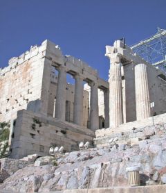
The Propylaia, Athens
This monumental gateway to the Acropolis was built by the architect Mnesikles from 437 to 432 BC. Certain details would never be finished. The building consists of a main hall on two levels, for the passageway leading to the Acropolis. The Doric order was used on the exterior; taller, slenderer Ionic columns lined the west portion of the central passageway. On the north-west, a small room decorated with wall painting and provided with benches offered a rest stop for pilgrims. An identical façade was erected on the south-west, but with no room behind.

Olynthos: Classical houses
This city in northern Greece, flourishing from 432 BC until its destruction by Philip II in 348 BC, has provided the biggest sample yet known of Classical period Greek houses. Blocks of adjacent houses sharing walls are neatly arranged on straight streets. As at Priene, houses have a central courtyard, with rooms arranged around it. In other respects, the houses at Olynthos are different. Behind the court lies a portico, the pastas, an intermediate space between the courtyard and the small rooms behind. Houses at Priene did not have this feature. In addition, many houses have an andron (men's dining room), a special room set apart from other rooms in the house. Supplied with benches set against the walls, on which the man of the family and his friends would recline as they dined, these rooms were frequently decorated with a floor mosaic – a touch of luxury not seen elsewhere in the house.

Floor mosaics
Floor mosaics were a characteristic feature of later Greek and then Roman cities, both in private houses and in public spaces. This mosaic tradition originated in the fifth century BC at Olynthos and Corinth. Two types of materials were used to make the designs, pebbles (naturally shaped and colored) and tesserae (cut pieces of stone, glass, or terracotta). Pebble mosaics were earlier; from the early Hellenistic period, mosaics of tesserae became standard. A spectacular example of an early tessellated floor mosaic is the "Alexander Mosaic" from the House of the Faun, Pompeii. The mosaic depicts the confrontation of Alexander the Great and the Persian king, Darius III, at the Battle of Issos. Made ca. 100 BC, it may copy a lost wall painting of the late fourth century BC.

Temple of Athena Nike, Athens
This small Ionic-order temple stood just south-west of the Propylaia on a prominent bastion. It was built in the 420s, during the opening decade of the Peloponnesian War. Its best preserved sculpture decorated the low wall that enclosed the adjacent terrace, or parapet; Nikai, or winged Victories, their dresses billowing and twisting in the wind, bring sacrificial animals to Athena.

The Erechtheion, Athens
This Ionic temple of highly irregular design sheltered a variety of cults, notably the shrine of Athena Polias, Athena as the patron deity of the city. The last of the great buildings of the Periklean program, it was built between 421 and 405 BC. Despite the difficulties of the war years, the workmanship is of high quality. Particularly striking is the south porch, with its six caryatid columns. The original interior plan is uncertain, for remodelings through the centuries destroyed the initial configuration.

The Late Classical period
Sparta was unable to capitalize on its victory in the Peloponnesian War, and in 371 BC its heretofore invincible army was defeated at the Battle of Leuctra. The victors at Leuctra, Thebes and its allies, and, in subsequent years, the Arcadian League, stepped into the power vacuum. But quarrels between city-states kept central and southern Greece weak. The region was conquered in 338 BC by a northerner, Philip II, king of Macedonia. Assassinated two years later, Philip was succeeded by his son, Alexander, who would soon fulfill his father's greatest ambition and march his army eastward against the Persians. By his untimely death in 323 BC, Alexander was master of the vast Persian Empire, stretching from Anatolia and Egypt to the Indus River.

The expansion of Rome
In the early fourth century BC, the Romans captured Veii, the closest Etruscan city. Following an attack by Gauls in 390 BC, the Romans retrenched, building their first fortification wall, the so-called Servian Wall in c. 380 BC. During the later fourth and third centuries, Rome conquered the entire Italian peninsula, plus the islands of Sicily, Corsica, and Sardinia. Conflict with Carthage, the powerful North African city of Phoenician heritage, resulted in a decisive Roman victory in 146 BC that gave Rome control over the west and central Mediterranean. In the second and first centuries BC, the Romans expanded in the eastern Mediterranean, often the result of intervention in the disputes between Hellenistic monarchs. Roman penetration into north-west Europe began with the campaigns of Julius Caesar in 58-51 BC. Control of the entire Mediterranean was consolidated in 31 BC, when Caesar's adopted son and successor, Octavian, secured Egypt for the Romans.

Roman roads, camps, colonia
In order to integrate their far-flung territories into the Roman state, an extensive network of roads, army camps, and new towns, or colonies, was developed.
Roads, at least the great intercity routes built by the state, were stone-paved, suitable for all weather, and well-maintained. Security was constantly monitored. Roadside establishments offered room, board, stables, mail, and other services for the traveler. Army camps were set up particularly in frontier zones. The layout followed a standard plan: a square enclosure, divided into four quadrants by two straight streets crossing at right angles, with the commander's tent in the center, the barracks and other facilities neatly arranged along the streets. This camp layout would provide a model for the plan of newly founded towns. Indeed, camps would often develop into permanent towns. Unlike a Greek colony, a settlement autonomous from the city that founded it, the Roman colony, or colonia, was established initially in order to assure military control or political domination of a region. Ostia, later developed as the port of Rome, was an early colony set up to protect the mouth of the Tiber. In later times, colonies were founded to relieve population pressure or to reward veterans with free land. The establishment of a colonia followed a set routine. The boundary of the town was fixed with religious rites; the land would then be professionally surveyed and subdivided.

Ostia
Ostia, the port of Rome , founded in ca. 350 BC as a fort (castrum) guarding the mouth of the Tiber River and the access to Rome, flourished through the Republic and Empire as a commercial harbor city, the key port of entry of grain brought to the capital. During the Middle Ages, as the economy declined, the harbor filled with silt, and malaria permeated the now swampy area, the city was gradually abandoned.

Royal burials
With the conquests of Philip II, Alexander the Great, and their Macedonian generals, kingship became a key factor in the Greek world – of interest to us, because the patronage of kings would play an important role in the development of Greek cities. As we have seen at Ur and in ancient Egypt, burials could serve as important expressions of wealth and power.

Royal burials: Vergina
At Vergina, an early capital of Macedonia, three tombs dated to 350-300 BC have been attributed to Philip II and members of his family. The structures are simple: a vaulted room with (in two cases) an antechamber; they were then covered with a low tumulus. Tomb I, whose occupant is unknown, contains a magnificent wall painting of Hades seizing Persephone, a rare example of the monumental narrative painting highly valued by the ancients.

Royal burials: Halikarnassos
The most famous above-ground funerary monument of the Late Classical period was the Mausoleum at Halikarnassos. This grandiose building was constructed over the tomb of Mausolus, the regional ruler, in the mid fourth century BC. Although the building was destroyed in the Middle Ages, its appearance can be reconstructed from ancient descriptions and from from modern archaeological exploration (Fig 17.15 in Ancient Cities). Measuring ca. 30m x 36m in ground plan, it rose ca. 42m in four stages: a tall base; a section surrounded by a temple-like colonnade; a pyramidal roof of 24 steps; and, on top, a statue of Mausolus and Artemisia, his wife and sister, in a quadriga (a chariot pulled by four horses). The greatest Greek sculptors of the age were commissioned to decorate the monument.

Late Classical Priene
The ruins of Priene, a small city located on a bluff overlooking the Meander River valley in today's south-west Turkey, offer an unusually well-preserved example of an ancient Greek city plan. Flourishing in the Late Classical and Hellenistic periods, Priene faded in the Roman imperial period, never to be rebuilt. As a result, archaeologists have been able to uncover the entire city plan, allowing us a look at an ancient Greek city in a comprehensive way that other cities, inhabited through the centuries, cannot give.
The city was fortified. Inside the walls, streets were laid out on a grid plan, in accordance with principles associated with the fifth-century BC urbanist, Hippodamos of Miletus, with adjustments made for irregular topography. Although small, Priene contained the public and private buildings characteristic of Greek city-states. The agora was lined with stoas, with a small temple on the east. Behind the north stoa lie the well-preserved bouleuterion (council chamber) and the prytaneion (seat of government officials). Uphill, a theater was built. To the west, the Temple of Athena, the principal shrine of the city, sits on its own impressive terrace. This Ionic temple of the fourth century BC was designed by Pytheos. Below the temple, a district of private houses has been uncovered. In a typical house, entrance is through a modest doorway into an interior courtyard. Rooms are arranged around the court, with one large and higher room (the oikos) at the rear. Below the city center lie the gymnasium and the stadium. The central hall of the gymnasium served as a schoolroom for boys; many carved their names on the walls. Cut into the south slope of the bluff, the stadium has a truncated plan to fit the restricted space.

Didyma: the Temple of Apollo
The colossal Temple of Apollo at Didyma, begun during the Hellenistic period, exemplifies both the continuation of the Greek temple tradition and the Hellenistic taste for the dramatic and the unexpected. The sanctuary at Didyma, under the control of the nearby city of Miletus, had long been renowned for its cult of Apollo with, as at Delphi, an oracle. The previous temple had been destroyed by the Persians in 494 BC, not to be rebuilt until after Alexander captured the region. The new temple was designed by the architects Paionios of Ephesus and Daphnis of Miletus. Construction continued through the Hellenistic and Roman imperial periods but was never completed.
The ground plan is unusual. The exterior conforms to the traditions of Ionic architecture, with a dipteral colonnade on a large rectangular stylobate. The interior, in contrast, is a surprise. An interior courtyard, entered from the pronaos through a pair of barrel-vaulted passages, contained at its west end a small temple to Apollo, with a spring sacred to the god – together, the seat of the oracle. At the east end of the court a broad flight of steps leads to a large chamber, the room from which oracular messages were delivered to inquirers. In 250 BC, well after the deaths of the initial architects, the north wall of the courtyard was carved with architectural plans. Rendered in finely incised lines, these diagrams show design details of the columns and other architectural elements, in order to ensure uniformity in measurement and form.

Alexandria
Founded by Alexander in c. 331 BC, Alexandria became the capital of the bicultural Ptolemaic kingdom of Egypt, its prosperity continuing during Roman imperial and early Byzantine times. Little has survived from the ancient city; descriptions of ancient writers, notably Strabo who visited in 25 BC, have been crucial for understanding its appearance. The city, located on flat ground, was organized in a grid plan. A causeway connected the mainland with the small island of Pharos; harbors lay on either side. Notable buildings included the palace and gardens; the Mouseion, a research center with a great library; the tombs of Alexander the Great and the Ptolemies; a temple to Serapis, a god who combined a Greek appearance (a mature man, bearded) with Egyptian mystic beliefs; underground cemeteries; and a monumental lighthouse, the Pharos, named after the island on which it stood.

Bicultural Egypt
The Ptolemies and their capital city, Alexandria, remained culturally Greek. However, the people they ruled were Egyptian, and they continued their traditions from earlier times. Accepting this reality, the Ptolemies built temples in Upper Egypt in purely Egyptian style, with figural decorations to match. Only the names indicate that the rulers shown with the gods were not Egyptian but Greek. In the cemeteries of Alexandria, however, some attempts at combining Greek with Egyptian motifs and styles were made, but the results were awkward.

Asklepios and Epidauros
Asklepios, a god of healing, first attained popularity in the Late Classical period. The center of his cult was located at Epidauros. In addition to the temple, the sanctuary contained buildings that served those coming for treatment. Unusual is the tholos, a round building with foundations of six concentric rings of tufa, a volcanic stone, perhaps the walls of an underground crypt used for cultic purposes. Evidence for the healing practices comes from ancient writings, including inscribed stelai offered as dedications from grateful patients. Some distance away lies the theater, the work of the architect Polykleitos in the late fourth century BC, an early example of a theater built of stone. This theater contains the characteristic features of a Hellenistic theater: built against a hillside; its seating area more than a half-circle; an orchestra; parodoi (open passages between the seating and the stage building); and a skene, or stage building (that survives here only in foundations).

The Hellenistic period
The term "Hellenistic" refers to the centuries of Greek ascendancy in the eastern Mediterranean and Near East after Alexander the Great's conquest of the Persian Empire. Following Alexander's untimely death, his generals divided the immense territory among themselves. Some, such as Ptolemy in Egypt and Seleukos in the Levant, Syria, and Mesopotamia, established long-lasting kingdoms. In this period of royal rule, the city-states and democracy of earlier times continued in name only.
The Romans, only a regional Italian power at the time of Alexander, were gradually drawn into the military and commercial affairs of the Hellenistic east, with accompanying territorial gains. By the end of the first century BC, the Romans controlled the entire Mediterranean. The eastern section of Alexander's empire, Mesopotamia and farther east, had earlier (second century BC) been taken over by the Parthians and other indigenous rulers.

Pergamon
Developed with funds left by Lysimachos, one of Alexander's generals, Pergamon became an important city in western Asia Minor. Until 133 BC, it served as the capital of the Attalid kingdom. Its early center was on a hilltop. The Attalid rulers fortified this acropolis, adding their palaces, military depots and barracks, a temple to Athena with commemorative sculpture in its precinct, a library, a theater, and, at a slightly lower level, the Great Altar. The sculptural decoration of the Great Altar was lavish; its themes were two, the battle of the gods vs. giants (repeating the allegory long familiar to Greeks, the battle between the forces of order and barbarism) and a pictorial narrative of the life of Telephos, the mythical ancestor of the Attalids. Down the hill a sanctuary of Demeter and a large gymnasium complex were built. The slopes also contained housing. In Roman times, the city expanded onto the plain at the foot of the acropolis hill. Two km to the south-west, a sanctuary to the healing god Asklepios was established in the fourth century BC. Its surviving remains are largely from a major refurbishing undertaken during the reign of the Roman emperor Hadrian (ruled 117-138).

Cosa under Republican Rome
Cosa, a colonia founded in 273 BC in territory formerly Etruscan, thrived until sacked by pirates in 70-60 BC. Subsequent habitation was modest. As a result, Cosa gives us a better glimpse of a city of the Republican period than, say, Rome or Ostia, cities that flourished during the later Empire.
Located on hilly ground by the sea, Cosa was laid out in a grid plan. The citadel, called the Arx, occupied the highest point; here was the Temple of Jupiter, the main shrine of the town. The forum, or city center, lay on lower ground, with civic buildings arrayed around an open rectangular space.
Architecture at Cosa includes an early example of the true arch, a design that would become a hallmark of Roman architecture. Used in the construction of this triple archway is concrete, a mixture of lime, sand, and water (and, in later times, volcanic dust) that hardened well – a favorite Roman building material. Walls of concrete would normally be faced with cut stones or brick, to give a regular appearance to the exterior. Well-known patterns of facing include opus incertum, opus reticulatum, and opus testaceum.

Sinope: a Black Sea port
Founded by colonizers from Miletus in the late seventh century BC, Sinope grew prosperous thanks to its location in the center of the Black Sea's southern coast, propitious for trade and communication by sea. Excavations have revealed extensive production of amphoras used to ship olive oil and wine to other cities throughout the Black Sea – a testimony to the city's commercial success. Land communications were poor, however, obstructed by the nearby Pontic mountains.
In addition, from 183 BC until the Roman takeover in 70 BC, the city served as a capital of the Pontic kingdom, which had emerged c. 300 BC as one of the many states that arose from the conflicts following the death of Alexander the Great. It continued to flourish during the Roman Empire.
Sinope is located at an isthmus on a dramatic peninsula that juts out to the east like a hook, offering a protected harbor on its south side. Little remains from the ancient city. The geographer Strabo described the city as follows: "The city itself is beautifully walled, and is also splendidly adorned with gymnasium and marketplace and stoas." These well-built walls still survive. They may date originally to the second century BC, when Sinope became the capital of Pontus. A grid plan seems to have been applied, if the modern street plan can be considered a reflection of the ancient layout. Other remains include foundations of a temple attributed to Serapis, dated to the second century BC, and traces of the mole in the southern harbor. Of Strabo's gymnasium, marketplace, and stoas, nothing survives.

Delos: a commercial center
A tiny island in the central Aegean long venerated as the birthplace of Apollo and Artemis, Delos became for a short time in the mid Hellenistic period (166-69 BC) a major commercial center, a free port where sales, purchases, and transshipments could be conducted without tax on the transactions. The slave trade was one of the businesses that flourished. This prosperity continued until 88 BC, when the island was sacked by the forces of Mithridates VI, with the final blow dealt by marauding pirates in 69 BC.
The city developed around the sheltered harbor on the island's west coast. The sanctuaries of Apollo and Artemis, founded much earlier, lay close by. Commercial and residential districts spread to the north and south of this central core. Some houses are magnificent, with peristyle courts decorated with mosaic floors. All are equipped with underground cisterns for the collection of rainwater, crucial on this otherwise waterless island.
Commercial complexes consist notably of agoras, warehouses, and the enigmatic Hypostyle Hall (Stoa of Poseidon). What types of goods (including slaves) were traded in each location is unknown. The largest of the agoras, the Agora of the Italians, may have had a special purpose. It lacks the altars and shrines seen in other agoras, places where oaths to the gods would be sworn, the binding element of any transaction. Instead, this agora, entered through a single propylon, consists of a large, rectangular court surrounded by a portico, with alcoves, a bath complex, and possibly a banquet hall beyond. In addition, it contained a bath complex and possibly a banquet hall. Perhaps it served as a recreational center for the large Italian community on the island. Although repaired after the massacre of Italians in the eastern Aegean in 88 BC, the building was abandoned in 60-50 BC as Delos fell into decline.

Imperial fora in Augustan Rome
The Forum of Augustus was the second of a series of five adjacent but self-contained civic spaces designed to supplement the crowded Forum Romanum. Together these are known as the Imperial Fora. The first, commissioned by Julius Caesar in 54 BC, set the pattern: a porticoed court with a temple, here a Temple to Venus Genetrix, ancestor of Julius. The Forum of Augustus, built in the first century BC, also consisted of a court lined with porticoes, a frame for the Temple of Mars Ultor at one end. New, however, were the semicircular spaces (hemicycles) beyond the colonnaded porticoes. As typical of the Augustan period, architectural decoration combined Greek details with Italic features. In this forum the administration of the provinces was centered; boys formally put on the toga, symbol of manhood; and commanders sent abroad began their missions and, when returning victorious, paid homage to Mars, god of war.
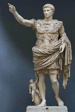
Augustus (ruled 31 BC-AD 14)
Augustus was the first of the Roman emperors, taking complete control of the Roman Empire after the Battle of Actium in 31 BC. The majestic marble statue of Augustus from Primaporta exemplifies his understanding of the power of images. The work combines Greek and Roman features, idealized and specific. The face is a faithful image of Augustus as a young man, in the realistic tradition of Etruscan and Roman portraiture. This youthful portrait would remain his standard image until his death. The body, however, is muscular, an idealized athletic body in the Greek tradition, as exemplified by the Discobolos. Augustus wears armor, recalling his military career. Relief sculpture on the cuirass carries a further message. The depiction of a Parthian returning captured standards to a Roman emphasizes the peace brought to the uneasy eastern frontier of the Roman Empire. Indeed, Augustus took great pains to stress his achievements in bringing peace to the Roman state after decades of strife.

Augustan architecture
According to Suetonius, Augustus declared he found Rome a city made of brick and left it made of marble. He realized the value of transforming the capital into an architectural showcase; he achieved his aim by integrating Greek forms and materials, such as marble, with traditional Italic features. Three buildings in particular illustrate his approach to architecture, symbols, and the image of his own personality: the House of Augustus, the Forum of Augustus, and the Ara Pacis.

The House of Augustus, Rome
The House of Augustus, located on the Palatine Hill near the model of the House of Romulus, the legendary founder of Rome, was a well-appointed but relatively modest residence of at least two storeys. Later emperors preferred lavish palaces, but for Augustus, moderation was important.

The Roman Empire
The two centuries following the death of Augustus marked the great period of prosperity and power for the Roman Empire. Its enormous territory, from Britain to Egypt, from Morocco to the Danube, was held successfully against both external and internal challenges. The army was an important element of stability. Stationed primarily along the frontiers, the army helped spread Roman institutions to these distant regions. The army camp, or castrum, often developed into a town; in addition, new towns were established to settle retired veterans. Farmers, merchants, and other providers of services prospered in these new communities. Other factors contributing to social and economic stability included the legal system developed in the Republic; a stable monetary system; and the well-maintained network of communications.

Rome: the imperial capital
The rule and patronage of emperors greatly affected the appearance of the city. Augustus had stressed continuity with what had come before; his modest lifestyle, for example, followed Republican ideals. His successors, however, preferred the opulent trappings of kingship popular in the Hellenistic world. They commissioned grandiose palaces for themselves, such as Nero's Domus Aurea, and majestic temples, commemorative monuments, and civic buildings for the public in a city whose population would swell to over one million. The extensive use of concrete transformed architectural design, allowing a variety of forms not possible in the hugely influential but conservative tradition of Greek architecture.

Palaces in imperial Rome
Sharp social differences in imperial Rome were mirrored in the city's housing. Most people lived in squalid, poorly built multi-storeyed apartment buildings. The wealthy lived in what must have been grand versions of Pompeiian houses. Few traces of these dwellings have survived, either the apartment buildings of the masses or the houses of the rich. Better preserved are residences of emperors: the Domus Aurea (the Golden House), the Flavian Palace on the Palatine Hill, and Hadrian's Villa at Tivoli. All were sumptuous, and each displays architectural innovations for which this period, mid first to mid second century, was distinctive.

Imperial civic buildings
In addition to temples and commemorative monuments, emperors donated civic buildings as expressions of their largesse and power. Well-known examples include the Colosseum, Trajan's Forum and Market, and the Baths of Trajan.

Temples in imperial Rome
Although religious architecture in imperial Rome remained conservative, based on Greek and Tuscan traditions, some striking innovations did occur. Two temples built during the reign of Hadrian, the Pantheon and the Temple of Venus and Roma, illustrate the combination of traditional and innovative materials and designs.
The Pantheon, a well-preserved temple to all gods constructed in the years 117-128, displays an unusual two-part design: a porch and, behind, a circular cella covered by a hemispherical dome. The deep porch with columns and pediment conforms to the traditions of Greek and Etruscan architecture. Marble is widely used. The cella, in contrast, is made largely of concrete, with brick and stone elements. The dome is decorated with coffers, and has an oculus, an opening to the sky, at the top.
The Temple of Venus and Roma, which survives only in ground plan, appears much more traditional. From the outside, the temple looked Greek: a rectangle surrounded by a peristyle. In other aspects, local Roman preferences came to the fore. Inside, the temple was divided into two cellas, one for the goddess Roma (Rome), the other for Venus. The basic material of the temple was concrete faced with brick, local products, but covered with marble imported from Greece.

Royal tombs in imperial Rome
Tombs are often vehicles for the prestige of the occupant or surviving successors, as witness the pyramids of Giza (Chapter 5) and the Mausoleum of Halikarnassos (Chapter 17). This need not always be the case, as the hidden tombs of Egyptian New Kingdom rulers attest (Chapter 6). The preferences of Roman emperors varied, from the grand to the simple. Examples of the grand include the mausolea of Augustus and Hadrian. The former is a circular mound formed by concentric concrete walls and covered passages, the whole covered by earth and decorated with trees. The latter, although it kept the circular form of the Mausoleum of Augustus, was a building, not an earth-covered mound. In modern centuries it served as a fortress for the papacy, a reminder that ancient buildings and monuments often have a life story that continues well beyond the end of antiquity.

Commemorative monuments
Imperial Rome was filled with commemorative monuments, of which the Arch of Titus and the Column of Trajan are well-known examples. Each was decorated with sculptural scenes that celebrated the military success of the donor.

Nîmes under Rome
Nîmes (ancient Nemausus) is located west of the Rhone River in southern France, beneficially placed on the Via Domitiana, the principal road from Italy to Spain. The Roman provincial city originated in pre-Roman times, an oppidum ("town," in Latin; used by the Romans to indicate the settlements of native peoples in western Europe) that served as the regional capital of the Volcae Arecomici, a Celtic tribe. A key attraction was a healing spring. Captured by the Romans in the later second century BC, Nîmes was reorganized under Augustus, ca. 27 BC, as a colony for veterans. Enclosed by a fortification wall, the city was laid out around the usual cardo and decumanus. Well-preserved Roman buildings include the so-called Maison Carrée, originally a Roman temple dedicated to Rome and Augustus, and the amphitheater.
During the prosperous second century AD, the architecture protecting the spring and its surroundings were renewed, with a nymphaeum, a theater, and a small temple (known as the Temple of Diana). Nearby are the remains of the castellum, a large circular settling basin in which fresh water brought by aqueducts was collected before redistribution to different parts of the city. The famous Pont du Gard (Figure 20.10) was one segment of the network of aqueducts used by ancient Nîmes.

Roman provincial cities
Chapter 24 examines selected cities from the Roman Empire outside its Italian heartland – Nîmes, London, Trier, Palmyra, Ephesus and Pergamon, Perge, Jerash, Athens, and Lepcis Magna. The main questions to ask while exploring these examples are two. To what degree do these cities resemble or differ from the Italian cities already presented, and from each other? What features (buildings, layout, services, etc.) constitute a Roman city?

Trier under Rome
Trier (Augusta Treverorum), a Roman provincial city of great political, cultural, and economic significance in, especially, the third and fourth centuries, lies on the Moselle River in south-west Germany, in territory occupied in pre-Roman times by the Germano-Celtic Treveri tribe. Founded under Augustus as an army camp, Trier eventually became the political and commercial center of the north-west Empire. In 395, however, the Romans abandoned Trier as an administrative center, for security reasons: military confrontations were increasing in the Rhine frontier zone. Soon thereafter the city was taken over by the Franks.
Little is known of the city's remains during the first century. In the second century, building activity was extensive. A grid plan is now attested, with, in the center, a large forum with a sunken cryptoporticus, an underground gallery. The important political status of the city is seen best in grand buildings erected during the later Empire. They include the Porta Nigra ("black gate"), the monumental Imperial Baths (Kaiserthermen), and the Aula Palatina ("palatial hall"), also known as the Basilica of Constantine. This last served as a royal audience hall, originally part of a palace complex.

Ara Pacis
The Ara Pacis Augustae, the Altar of Augustan Peace, is a modest-sized (ca. 10m2) free-standing altar designed for sacrifices to the goddess Pax, or Peace. The monument, voted by the Senate in 13 BC, officially dedicated in 9 BC, commemorates the peace brought to the Roman state by Augustus, and discreetly honors Augustus as a new founder of the city and state. The altar, a low table, lies in the center of a square enclosure, an open-air space. Two doors on opposite sides give access to the interior. The exterior is decorated with two bands of relief sculptures. Elegant floral patterns are carved below. Of particular interest are the scenes carved in the upper band. The two doorways are flanked by panels that illustrate the divine and heroic underpinnings of the state. Included are depictions of the goddess Roma seated on armor, the symbol of peace through conquest, and the she-wolf suckling the infants Romulus and Remus, the eventual founders of the city. On the two sides without doors, the reliefs show a completely different subject. Men, women, and children walk in procession, in calm, dignified, but relaxed fashion, to attend the celebration of the laying of the foundation stone of the altar in 13 BC. Augustus walks among them, but he is inconspicuous, in keeping with the modest public persona he liked to project. The theme emphasized by the Ara Pacis procession is the orderly, beneficial rule of Augustus and his family.
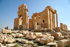
Palmyra under Rome
Located in an oasis in the Syrian desert, the Roman provincial city Palmyra prospered from the late Hellenistic period to the late third century AD as a caravan stop on the trade route between the Mediterranean coast and Mesopotamia. Although the city belonged to the Empire, its inhabitants were Semitic. In appearance, the city shows a blend of typical Roman with local traditions. Its architecture and layout, with its main colonnaded street, arched gateways, and theater, are firmly Roman in style. In contrast, temples and tombs differ, for they reflect local religious practices. The cultural blend is seen in the Temple of Bel: classical on the outside, inside a non-classical plan, a central hall with separate shrines at either end. Burials were made in multi-storeyed towers erected in the desert west of the city. Each tower contained long rectangular compartments for the bodies, with a stone plaque carved with a bust of the deceased sealing the opening.

London under Rome
In contrast with Nîmes, the Roman provincial city of London (Londinium Augusta) was not founded on a pre-Roman settlement. The site was selected for its advantageous location: the place closest to the mouth of the Thames River where the river could be bridged. As a crossroads, the town developed as a commercial center; by the later Empire it was of important rank. The remains of Roman London survive in fragments, recovered here and there below the center of today's metropolis. The rectangular-shaped city was divided into two parts by the Walbrook, a stream that flowed into the Thames, and laid out on a grid plan. Early settlement was concentrated in the eastern half. A major find dating to the second century was a Temple to Mithras, a god probably of Persian origin. This cult was popular especially among the army stationed along the empire's frontiers.
A wall was eventually built around the city in the early third century, including along the riverfront, enclosing an area of 132ha, making London the largest town in Roman Britain. This fortification, replete with added towers, would continue to serve the town into the Middle Ages.

Pompeii
This medium-sized city of the late Republic and early Empire and its neighbors, such as Herculaneum, occupy a special place in Roman archaeology. Buried under volcanic debris when Mount Vesuvius erupted in AD 79 and never rebuilt, the ruins of these cities are exceptionally well preserved. Explorations began in the eighteenth century, the first major archaeological excavations on a Classical site. Systematic excavations began in the 1860s and have continued ever since.
Pompeii was first settled in the sixth century BC. By the fifth century BC, the city was controlled by the Samnites, a local people related to the Latins. Even after the Roman takeover in the early third century BC, the city remained ethnically Samnite until the Roman general Sulla established a veterans' colony in the first century BC. During the first century AD, Pompeii prospered as a commercial and farming center, with a population of 10,000-20,000. Its chief products included wool, flowers and perfume, and garum, a pungent fish sauce.

Town plan, Pompeii
The earliest habitation at Pompeii lay in the south-west, a small area with irregular streets. A grid plan was applied when the town expanded north of the forum. In the third century BC, the town was walled. Expansion continued into its eastern sectors, with a new building boom when Sulla's veterans arrived.

The forum, Pompeii
The Pompeiian forum and its surrounding area contained the city's most important group of public buildings. The forum itself consisted of a long, narrow rectangular space, lined by porticoes and dominated at one end by the Temple of Jupiter. Hidden behind the porticoes were other religious buildings, a Temple of Apollo and a temple to the deified emperor Vespasian. Civic buildings occupied the south end, including a basilica, placed at right angle to the forum. The area also contained commercial buildings, such as the macellum (a complex containing the meat and fish markets) and Eumachia's building, a guild hall for the city's wool processors, so named after the wealthy woman who donated it.

Street life, Pompeii
The many streets in Pompeii have yielded good evidence for daily life. Several were paved with lava blocks and provided with sidewalks, kerbs, and large stepping stones at intersections to protect the pedestrian from mud and sewage. The many shops included wine shops or snack bars (thermopolia) and a mill and bakery. Graffiti were everywhere, personal, political, and commercial; some are erotic, sex and love being popular topics.

Entertainment in Pompeii
Pompeii contained a full complement of theaters. In the south part of the city, a large horseshoe-shaped theater was built against a hillside, in the Greek manner. Originally from the late third or early second century BC, it was remodeled in Roman fashion during the Augustan period. An odeum, or small roofed theater used for concerts and recitals, was located next to the theater. Behind the theater lay a large porticoed square. At the time of the city's destruction, this portico served as a barracks for gladiators. Skeletons of at least 52 individuals including children were discovered, people who had collected here intending to flee the city when the volcano erupted.
An amphitheater was built in 80 BC in the far south-east corner of the city. The name means "double theater," and such buildings were indeed round or, as at Pompeii, oval. Pompeii's amphitheater, an early example, was partly sunk into the ground, its floor thus lying below ground level. Its capacity is estimated at 20,000. Amphitheaters were developed for such specifically Roman spectacles as gladiatorial combats, fights with wild animals, and even (if an amphitheater could be filled with water) mock naval battles.

Baths, Pompeii
Public baths were an important institution of the Roman world, places for cleaning oneself and for exercise, relaxation, cultural events, and social and business encounters. Men and women bathed separately, either in different sections of a bath complex or, if the complex were small, at different hours.
Pompeii had four large public bath complexes and many smaller ones at the time of its destruction. The earliest was the Stabian Baths, originally built in the second century BC. The plan is irregular, but contains the key rooms of a typical bath complex: a changing room (apodyterium), a warm room (tepidarium), a hot room (caldarium), and a cold room with a small cold pool (frigidarium). The Stabian Baths were also provided with a large outdoor swimming pool (natatio), a court for exercise (palaestra), smaller rooms, and a latrine. The warm and hot rooms were heated from below; the floor was raised on piles of bricks, so that hot air from central furnaces could circulate in the free space. In the colder climates of the northern Empire, the walls were typically fitted with flues for hot air, to augment the heating. The Roman bath culture depended on regular supplies of fresh water, brought from distant sources by aqueducts. When the aqueduct system fell apart in western Europe during the Middle Ages, bathing became a rarity.

Houses, Pompeii
The many well-preserved houses rank high among the important finds at Pompeii. Built at different times during the Republic and the early Empire, the houses document developing architectural and decorative styles with a completeness unparalleled in the Roman world. Two favorite design units are the atrium and the peristyle court. The atrium, probably a legacy from the Etruscans, consists of a main room with an opening to the sky and a basin below, to catch the rain. Five different types of atrium houses were described by the Roman architect Vitruvius. In the Tuscan version of the atrium house, the ceiling is held up by strong rafters. The House of the Surgeon is an early example of this type, built originally in the fourth century BC. Another popular atrium design, the tetrastyle, features four columns that supported the ceiling. In all types, off the atrium lie smaller rooms, and, at the rear, the two important rooms, the main reception room (tablinum) and the dining room (triclinium).
Peristyle courts, that is, courts surrounded by a porticoed colonnade, were included in houses of the well-to-do. At Pompeii, the courtyard was normally planted as a garden. Peristyle courts have an ancestry in Greek architecture, although typically a court would not be used as a garden. Examples of large, wealthy houses at Pompeii that contain both an atrium and a peristyle court include the House of the Faun and the House of the Vettii.

Wall paintings, Pompeii
The destruction wreaked by Vesuvius has preserved countless wall paintings at Pompeii, the largest surviving body of Roman paintings from the late Republic and early Empire. Following the work of the late nineteenth scholar August Mau, the paintings are traditionally divided into four stylistic groups. The first style imitates masonry; subsequent styles feature figural imagery and three-dimensional architectural scenes, often set inside complex frames. The most famous of the Pompeiian paintings are found in the Villa of the Mysteries, a large house located in the countryside outside the city. On the four walls of a medium-sized room, paintings depict the initiation of a young woman into the secret religious rites, or Mysteries, devoted to the god Dionysos.

The Colosseum, Rome
The Colosseum (Flavian Amphitheater), the most famous amphitheatre in Rome, was built during the reigns of Vespasian and Titus (finished in 80). Its common name, popular from AD 1000 on, is a reference to the colossal statue of Sol (the Sun) that stood nearby. The building was used for gladiatorial games and for spectacles with wild animals, including hunting, for a capacity crowd estimated at 45,000. Oval in form (amphitheaters, or "double theaters," were round or oval), the Colosseum was erected on flat ground, four storeys supported on vaulted passages.

The Arch of Titus
The Arch of Titus is a monumental free-standing single arch made of stone. Built after 81 by the emperor Domitian, the arch commemorated the suppression eleven years earlier of a Jewish revolt in Jerusalem by Titus and Vespasian, Domitian's brother and father. Two panels of relief sculptures placed on the walls inside the arched passageway illustrate the triumphal procession that followed this victory. In one panel, Titus rides in his chariot pulled by four horses guided by Roma, the personification of Rome, with the winged goddess, Victory, crowning him from behind. The second panel shows another moment in the procession, the carrying of important spoils from the Hebrew Temple in Jerusalem, the menorah, a gold table for ritual objects, and ceremonial horns.

Roman residential buildings
The term "insula" (pl. insulae), lit. "island," denoted a city block and also a multi-storeyed apartment building. They supplied 90 percent of the housing in Rome, but survival of these apartments has been poor. In Ostia, preservation has been much better. In appearance, these buildings resemble warehouses. Apartments could be spacious, with a wide corridor giving access to several small rooms. The larger reception and dining rooms lay at either end. Utility rooms might include a kitchen, but for hygiene, common toilets on the ground floor were the norm. The ground floor also provided running water and an oven for baking – reasons why apartments on the ground floor were the costliest.

Baths of Trajan
Public baths continued to be an important element of Roman social life. The capital had numerous baths to serve its large population. Thanks to the properties of concrete, they could be large, with huge vaulted spaces. Emperors of the later Empire often chose the bath complex as an appropriate way to provide a public service and to express imperial grandeur. The Baths of Trajan (dedicated in 109) represented an important step in the monumentalization of the bath complex. Although following traditional designs, these baths are three times the size of the Baths of Titus, an important predecessor, and would serve as a model for the later baths of Caracalla (211-216) and Diocletian (ca. 298-306). In order to serve a variety of social and entertainment purposes, the complex contained lecture rooms, libraries, meeting rooms, and gardens, in addition to the usual bathing facilities.

Roman Ephesus and Pergamon
Like Athens, Ephesus and Pergamon were already important cities in pre-Roman times. Both would remain large, prosperous, and important provincial administrative centers during the Empire. The diverse religious beliefs that characterized the Empire are attested here by temples to syncretistic cults. The Temple of Serapis at Ephesus and the Red Hall at Pergamon both demonstrate a mingling of Egyptian cults with Greek and Roman religions. Moreover, both buildings display an Egyptian monumentality, while using Greek architectural forms (the Temple of Serapis) or baked bricks and concrete (the Red Hall), materials much loved in Italy but infrequently used in Roman Asia Minor.

Trajan's Column
Trajan's Column, erected in Trajan's Forum between the Greek and Latin libraries, is decorated with a long spiral of relief sculpture that illustrate this emperor's victories in Dacia (modern Romania) in the early second century. The sculpture provides a pictorial record of a military campaign unparalleled in ancient art: battles, preparations, marching, transporting, the rivers and hills, the camps, with over 2,500 figures in 155 scenes.

Trajan's Forum
Trajan's Forum was the last, largest, and most complex of the imperial fora (see Chapter 21). Designed by Apollodorus of Damascus and dedicated in 113, this forum consisted of several parts: a porticoed square with exedrae on the north and south; a basilica; two libraries with Trajan's Column in between; and a temple to the deified Trajan.

Trajan's Market
This large commercial complex, at least six storeys high, lies immediately north of the porticoed square of Trajan's Forum. Its more than 170 rooms and halls have been identified as shops and offices devoted to selling food and to governmental activities. The large basilical hall off the Via Biberatica (the main street, on the third level) is noteworthy for its ceiling, a clerestory crossed by seven intersecting vaults (groin vaults) supported on piers – an innovative structure that would recur in the huge bath buildings of the later Empire.

Perge under Rome
A prosperous agricultural city on the Mediterranean coast of Asia Minor, Perge lay on slightly sloping ground at the foot of a flat hill first settled in much earlier times. Laid out in a rough grid, the city centered on a broad main street lined by porticoes with shops. Here, as elsewhere, wealthy benefactors contributed significantly to the well-being of the city. Unusually, the most famous benefactor of Roman Perge was a woman, Plancia Magna. The leading force of her distinguished family, in the early second century Plancia Magna renovated the city gate, built in the Hellenistic period, adding a horseshoe-shaped court, adorned with two levels of statues of prominent citizens, and a monumental triple archway at the north end of the court.

Jerash (Gerasa) under Rome
Founded in the Hellenistic period, this city located in today's Jordan is important for the preservation of its city plan and its buildings from its Roman period. The city straddles a small river; excavations have taken place on the western slope, outside the modern town. The ancient city plan follows for the most part a standard grid, but includes fascinating eccentricities, the result of survivals from pre-Roman settlement and topographic irregularities. Notable are the Oval Forum, a large space where the cardo, the main north-south street, changes direction slightly, and two tetrapylons at two locations along the cardo. The grand Temple of Artemis, built in the second century, sits toward the rear of a porticoed platform, dramatically positioned at the top of a broad flight of steps.

Athens under Rome
Although Athens under Rome had been replaced by Corinth as the major commercial and administrative city of the Greek peninsula, it retained considerable prestige as an intellectual and cultural center. When a Roman emperor wished to emphasize his philhellenism, he would donate a magnificent monument to Athens. Two such emperors were Augustus and Hadrian. Hadrian visited the city in 133 AD and donated a monumental gate to remember the occasion. Other benefactions included a library and the completion of the Olympieion, a huge temple to Zeus begun in the late sixth century BC and much advanced, but not finished, in 175-164 BC.

Commercial buildings, Ostia
Ostia has yielded much evidence for commercial complexes, warehouses, and shops. Warehouses include the Horrea Epagathiana et Epaphroditiana, built by two freedmen, Epagathus and Epaphroditus, during the reign of Antoninus Pius (138-161). The exterior, at street level, contained shops. The interior of this multi-storeyed building consisted of a central court surrounded by porticoes, with rooms beyond. Stairs led to offices and private apartments on the upper storeys.

Lepcis Magna under Rome
Founded before 500 BC by Phoenician or Punic settlers, this city on Libya's Mediterranean coast came under Roman control in the first century BC. Its prosperity depended on trans-Saharan trade, bringing into the Roman world such products as ivory, wild beasts for the arenas, gold, ebony, and ostrich feathers. When native son Septimius Severus became emperor (ruled 193-211), the city took on a new luster, thanks to his lavish benefactions. The major building projects of this period were a colonnaded street, a tetrapylon, a new forum with basilica, and a remodeling of the harbor. These buildings have counterparts elsewhere in the empire. What is distinctive is the ambition and richness of the program: many projects completed in a 20-year period, and the abundant use of expensive imported marble and granite. Among the cities presented in Chapter 24 of Ancient Cities, Lepcis Magna shows best how imperial favor could make a major difference in the appearance of a medium-sized city.

Late Antiquity
In the third century, after the Severan dynasty, the Empire entered a turbulent period. The office of the emperor was unstable, lacking an effective mechanism to regulate the succession. At the same time, threats from outside increased, from Goths and other Germanic tribes of northern Europe and from the Sassanian Persians to the east. In response, the emperor Aurelian had a new fortification wall built around Rome, the capital, the first since the Servian Wall of ca. 380 BC. The Aurelian Wall (begun in 271) enclosed a much larger area than its predecessor, a reflection of the growth of the city.
Despite the reforms of Diocletian (ruled 284-305), conflict in the imperial succession continued. After nearly 20 years of strife, Constantine defeated all rivals, becoming the sole ruler of the Empire. He admitted Christianity into public life and moved the capital eastwards, to Byzantium, two changes among many in Roman society that would take place in the fourth and fifth centuries.

Rome in Late Antiquity
Emperors continued to donate buildings in the capital. Among the most important, the massive Baths of Diocletian, the Basilica of Maxentius and Constantine, and the Arch of Constantine are all examples of types of buildings and monuments already familiar from earlier times. New in the fourth century will be public churches, for Christian worship.

Palaces in Late Antiquity
Two palaces of the late third through early fourth centuries illustrate changes in this period. The Piazza Armerina, a sprawling country villa in inland Sicily, recalls the earlier Hadrian's Villa. Its floor mosaics have survived well (Figs 25.1 and 25.2 in Ancient Cities). Diocletian's Palace at Split followed a different approach. This fortified palace, almost square, with two main streets crossing, gives the feeling of a traditional military camp. In keeping with contemporary styles, in contrast, are the pediment with an arcuated void, used at the end of a peristyle court, and the emperor's mausoleum, an octagonal building, a design that would pass into Christian architecture as the martyrium.

The Basilica Nova, Rome
Begun by Maxentius in 306-310 and finished by Constantine after 313, the enormous Basilica Nova (also called the Basilica of Maxentius and Constantine) was erected on the north side of the Forum Romanum. A colossal seated statue of Constantine was added in the west apse. In a tradition going back to the Ancient Near East, the statue was composed of different materials: a brick core; the body made of wood covered by bronze; and the head and limbs of Pentelic marble.

The Arch of Constantine
This triumphal arch, with three arched passages, was built in 312-315 to commemorate Constantine's victory over Maxentius at the Milvian Bridge. Its sculptural decoration is eclectic. Panels were taken from second century monuments – roundels from the Hadrianic period, and rectangular plaques from the period of Marcus Aurelius – and placed in the upper reaches of the arch. Lower down, and on the short sides as well, six frieze panels made in the time of Constantine illustrate episodes in the emperor's rise to power. Unlike the Classical style used in the Hadrianic and Aurelian panels, this frieze is carved in the medieval style. The juxtaposition of old and new styles on this imperial monument is striking.

Churches in Late Antiquity
The Edict of Milan, 313 AD, granted Christianity the status of a legal religion. Soon after, Christian churches were openly built. The first major church in Rome was St. John Lateran (later much rebuilt). On the west bank of the Tiber, above the tomb of the apostle Peter, another major church was erected: Old St. Peter's basilica.

Jerusalem in Late Antiquity
After the suppression of the Bar Kochba revolt of 132-135, Hadrian renamed the city Aelia Capitolina, and replanned it in the Roman fashion, with a cardo and a decumanus and, at their crossing point, a forum. During the reign of Constantine, the Christian significance of the city was highlighted. A tomb identified as that of Jesus was identified during construction of a cathedral at the north side of the forum. A round martyrium was built to shelter this tomb, the Rotunda of the Anastasis (Resurrection), the culminating element in a four-part complex of atrium court, basilica church, second courtyard, and rotunda. This complex, the Church of the Holy Sepulchre, would be a major destination for Christian pilgrims.

Rome: Old St. Peter's
Although this church was destroyed to make way for the Renaissance-Baroque St. Peter's still in use today, its plan and appearance are well-known from written and pictorial sources. It was a basilica, an adaptation of a traditional Roman civic building for Christian use. Like the standard Roman basilica, Old St. Peter's was divided into a central nave (with a clerestory) and side aisles. Entry was through a short side, with an apse forming the opposite end. In front of the apse was the altar; the saint's tomb lay below. The interior was lavishly decorated. The church became popular as a burial site, for it was desirable to be buried near a great saint.

Constantinople, the "New Rome"
In 330, Byzantium, a city of modest importance in earlier Greek and Roman history, was dedicated as the new capital of the Roman Empire. This change reflected the growing importance of the eastern half of the Empire, and a strategic location closer to the eastern and Danube frontiers. Its position as a crossroads between Europe and Asia, and its command of the straits (the Bosporus) leading from the Sea of Marmara to the Black Sea would earn the city its role as an imperial capital for 1,600 years, first Byzantine, then Ottoman.
Little remains from the Constantinian period, but literary sources describe the transformation of the city into a worthy capital. A large area was walled; the main street (the Mese) and an oval forum (the Forum of Constantine) were key elements of the new city plan. Prestige objects were brought from other parts of the empire to lend distinction and to connect the new city – and the newly recognized religion – with imperial traditions. Both pagan and Christian items were placed in the base of the Column of Constantine, the central monument in the oval forum. The hippodrome, the immense stadium for chariot races, was decorated with such items as the Serpent Column from Delphi, a bronze monument that originally celebrated the Greek victory over the Persians at Plataea in 479 BC. Constantine himself would be buried in a round mausoleum, a martyrium; next to it stood, eventually, the Church of the Holy Apostles, the burial site of Byzantine royalty for several centuries.